
Country Thailand Time zone THA (UTC+7) Area 810 km² Geocode 6706 | Seat Khok Sa-at Postal code 67170 Province Phetchabun Province | |
 | ||
Si Thep (Thai: ศรีเทพ) is the southernmost district (Amphoe) of Phetchabun Province, Thailand, located in the Pa Sak valley.
Contents
Map of Si Thep District, Phetchabun, Thailand
History
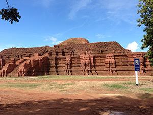
Higham reports of a 7th-century Dvaravati inscription from Sri Thep that states, "In the year...a king who is nephew of the great King, who is the son of Pruthiveenadravarman, and who is great as Bhavavarman, who has renowned moral principles, who is powerful and the terror of his enemies, erects this inscription on ascending the throne." A moat enclosed 4.7 square km, while the Khao Klang Nai structure dates from the 6th to 7th century. Prang Song Phi Nong and Prang Sri Thep were built in the 11th to 12th centuries.
The district was created on December 13, 1970 as a minor district (King Amphoe) with territory from Wichian Buri district. It was upgraded to be Amphoe Si Thep on August 8, 1976.
The ancient city of Si Thep was built in Khmer era. Prince Damrong found the area of the old city in 1905 when he visited Monthon Phetchabun. It is now the Si Thep historical park.
Geography
Neighboring district are (from the north clockwise) Wichian Buri of Phetchabun Province, and Lam Sonthi, Chai Badan and Khok Charoen of Lopburi Province.
Administration
The district is subdivided into 7 subdistricts (tambon), which are further subdivided into 93 villages (muban). The township (thesaban tambon) Sawang Watthana covers parts of the tambon Sa Kruat. There are further 7 Tambon administrative organizations (TAO).