
Country Thailand Time zone ICT (UTC+7) Area 3,296 km² Province Kanchanaburi Province | Seat Dan Mae Chalaep Postal code 71250 Population 23,700 (2005) Geocode 7104 | |
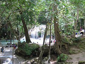 | ||
Points of interest Erawan National Park, Srinagarind Dam, Erawan waterfall, Huay Mae Khamin Waterfall, Sinakharin Dam Ridge Viewpoint | ||
Si Sawat (Thai: ศรีสวัสดิ์) is a district (amphoe) in Kanchanaburi Province, western Thailand.
Contents
Map of Si Sawat District, Kanchanaburi, Thailand
Geography
Neighboring districts are (from the north clockwise) Ban Rai of Uthai Thani Province, Dan Chang of Suphanburi Province, Nong Prue, Bo Phloi, Kanchanaburi, Sai Yok and Thong Pha Phum of Kanchanburi Province.
The district is dominated by the Si Nakharin Reservoir, which is part of Khuean Srinagarindra National Park. The 140 metre high Si Nakharin Dam was finished in 1980 and creates a 419 km2 impoundment of the Kwae Yai River. The dam has received criticism for being built on the Si Sawat fault line.
To the south of the district is Erawan National Park, best known for its Erawan Waterfall.
Administration
The district is divided into six sub-districts (tambon), which are further subdivided into 33 villages (muban). The township (thesaban tambon) Erawan covers parts of tambon Tha Kradan. There are a further six tambon administrative organizations (TAO).