
Country Thailand Time zone THA (UTC+7) Area 2,051 km² Geocode 6405 | Seat Hat Siao Postal code 64130 Province Sukhothai Province | |
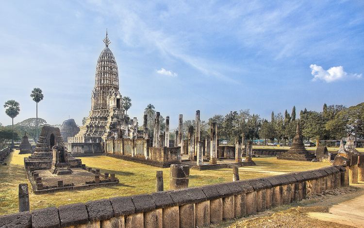 | ||
Points of interest Si Satchanalai Historical, Wat Chedi Chet Thaew, Golden Clothing Sathon M, Wat Chomchuen, Wat Chedi Kao Yod | ||
Si Satchanalai (Thai: ศรีสัชนาลัย) is the northernmost district (Amphoe) of Sukhothai Province, in the lower northern region of Thailand. Si may also be transliterated as Sri.
Contents
Map of Si Satchanalai District, Sukhothai, Thailand
Geography
Neighboring districts are (from the southwest clockwise): Si Nakhon, Sawankhalok, Thung Saliam of Sukhothai Province, Thoen of Lampang Province, Wang Chin of Phrae Province, Laplae and Tron of Uttaradit Province.
The Phi Pan Nam Mountains dominate the landscape of the district.
History
Si Satchanalai was the second-most important town of the Sukhothai kingdom. The ruins of its temples are now part of the Si Satchanalai historical park, which is part of UNESCO world heritage site of Sukhothai.
The district was renamed from Hat Siao to Si Satchanalai in 1939.
Administration
The district is subdivided into 11 subdistricts (tambon), which are further subdivided into 148 villages (muban). There are two townships (thesaban tambon) - Hat Siao covers parts of tambon hat Siao, and Si Satchanalai cover the whole tambon Si Satchanalai, Tha Chai and parts of Nong O. There are further 8 Tambon administrative organizations (TAO).