
Sub-provincial city Changchun Postal code 1306XX Area 1,677 km² Population 377,803 (2010) | Time zone China Standard (UTC+8) 4 Erdao Local time Sunday 7:10 PM Province Jilin | |
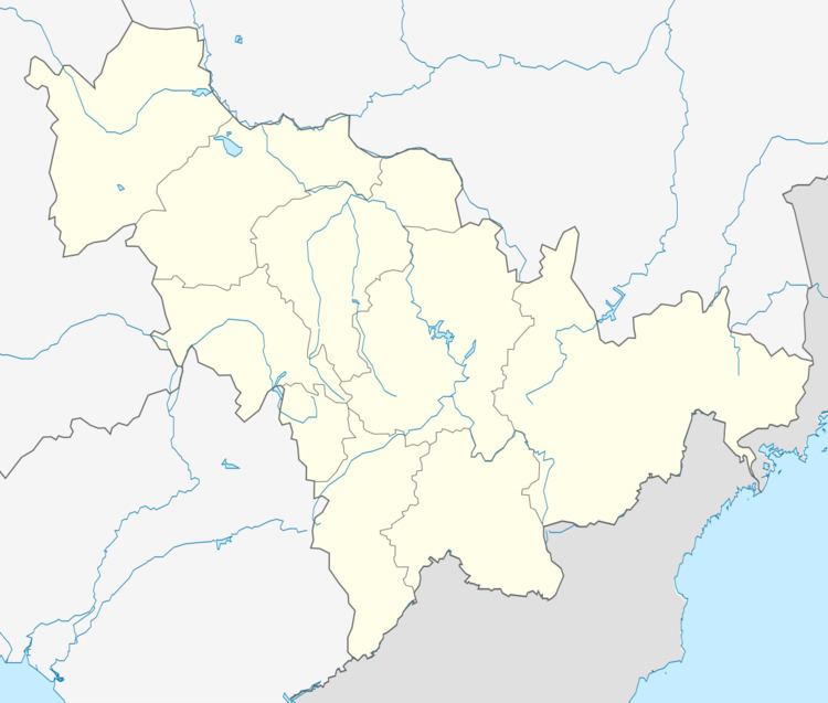 | ||
Country People's Republic of China Changchun district map Subdivisions of Changchun, Jilin
1
2
3
4
5
6
7
8
9
10
Core
1
Nanguan
2
Kuancheng
3
Chaoyang
4
Erdao
5
Luyuan
Suburban
6
Shuangyang
Satellite
8
Jiutai
9
Yushu
10
Dehui
Rural
7
Nong'an Co. Weather 10°C, Wind NW at 11 km/h, 30% Humidity Points of interest Shuangyanghu, Diaoshuihu National Forest Park, Shitou Koumen Reservoir | ||
Shuangyang District (simplified Chinese: 双阳区; traditional Chinese: 雙陽區; pinyin: Shuāngyáng Qū) is one of six districts of Changchun, the capital of Jilin province, People's Republic of China, forming part of the city's southeastern suburbs. Despite its name, it lies more than 40 kilometres (25 mi) southeast of the urban centre. It borders the districts of Erdao to the north and Nanguan to the northwest, as well as the prefecture-level cities of Jilin to the south and east and Siping to the southwest.
Contents
Map of Shuangyang, Changchun, Jilin, China
Administrative divisions
There are 4 subdistricts, 4 towns, and 1 ethnic township.
Subdistricts:
Towns:
The only township is Shuangyingzi Hui Ethnic Township (双营子回族乡)
References
Shuangyang District Wikipedia(Text) CC BY-SA