
Population 2,631 Civil parish Eastcotts Region East Area 73 ha Dialling code 01234 | OS grid reference TL072594 Unitary authority Country England Local time Sunday 7:10 AM Ceremonial county Bedfordshire | |
 | ||
Weather 6°C, Wind W at 10 km/h, 95% Humidity | ||
Shortstown is a large village located at the north of the Eastcotts parish on the outskirts of Bedford.
Contents
- Map of Shortstown Bedford UK
- Transport
- Shorts Building and Airship Sheds
- Village history
- Education
- References
Map of Shortstown, Bedford, UK
Before Shortstown was built, a windmill stood on the site from the 13th century to the 16th century, and from the 17th to 18th century the area was known as Windmill Hill.
The village was originally built by Short Brothers for its workers, but evolved into a settlement for people working at the RAF Cardington base.
The population of Shortstown is 2,401 (as of 2011) There is a social club, two convenience stores, a food bar, A pharmacy and a school named Shortstown Primary School.
Shortstown started with the establishment of the Airship Works in 1917, when housing for the workforce was built next to the airfield. In 1918 and 1927, sheds (later Grade II* listed buildings) were built for the R100 and R101 airships which then represented the latest passenger flight technology.
South of Shortstown there is a woodland created by the Forest of Marston Vale called Shocott Spring.
Transport
Transport in Shortstown provides links between the town and other parts of England. Road access to the village is provided by the A600 road.
Shorts Building and Airship Sheds
The main Shorts Building was built next to what is now the A600 road was a hotel for air passengers, but was never completed because of the demise of the airship as a mode of passenger transport following the loss of the R101 in October 1930. Later the building was used by RAF Cardington for teaching and administration and as an officers' mess. The building was refurbished in 2011 and a new site called New Cardington was also built.
Village history
Shortstown is built on Tinkers Hill, Harrowden. Shortstown may stand on the site of an ancient sacred shrine.
Early in 1916 the Admiralty was seeking sites for an airship works for Messrs. Short Brothers and after a two-month search the Naval Director of Air Services reported in March 1916 that a site had been selected at Cardington because it was well served by roads and railways, and was in easy reach of London by steam train therefore, easy for the Admiralty to maintain close liaison with the factory and there was a broad, flat valley running east-west without any obstructions, thus providing a sufficient manoeuvring area to handle rigid airships.
The whole site was bought by the Admiralty from the Whitbread Estate for £110,000 and in October 1916 Short Brothers made proposals for housing the employees required at the airship works. They estimated that for 1917 they would require 800 workers, 500 men and 300 women – of which 200 (mainly women) they hoped to obtain in Bedford. The rest would be houses in an entirely new "Garden City" type settlement alongside the works.
Shortstown initially grew quite quickly, with housing laid out in a Garden City style. Examples are to be found on the Crescent, North and South Drives and Central Avenue. This aimed for a green, open residential neighbourhood in a settled suburban environment with formal road geometry, grass verges, hedges and trees.
The War Department acquired the airfield from the Shorts Brothers in the 1920s which marked the end of civilian airship production on the site. Air force personnel occupied the houses. Over the years, more standardised housing was built by the Ministry of Defence, which conflicted with the style of earlier development.
In the late 1930s and 1940s, RAF Cardington was an induction centre and holding station for new recruits. From the mid-1950s it was used by RAF 217 Maintenance Unit which closed in 2000. By then the military presence had dwindled substantially and the military had sold many of the houses, mainly to Bedford Borough Council, who later transferred many of them to a housing association.
Since 2012 there has been significant investment made by local small businesses. Shortstown now has very modern McColl's shop with a Surgery nearby. There is a new pharmacy that is located in New Cardington along with Tesco Express and a Food Bar. Cash points are located by McColl's and Tesco Express.
The former RAF Cardington Camp occupies an area of approximately 45 hectares (112 acres) and lies directly to the east of the A600, linking Bedford with the A507 and Hitchin. The site rises from the valley floor formed by the Elstow Brook and extends to the south, up to the ridge on which Shortstown now stands.
There is significant housing development on land to the east of the A600, this part of the village is marketed as New Cardington to appeal as more upmarket then Shortstown. Over half of homes on New Cardington development are for Housing Associations.
Since New Cardington homes went on the market, house prices in old Shortstown have risen by more than 20%, probably because of the larger size of old homes and exceptionally large gardens.
Proposed development has been created, houses will surround the Cardington hangars and extend to Cotton End. Harrowden and Cotton End will also be getting some development too!
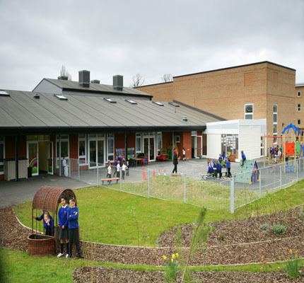
Education
A New school named Shortstown Primary School started construction in late 2012 and completed in September 2013, replacing the old school named Shortstown lower school. The School was also relocated to Beauvais Square, opposite to Tesco Express.