
- elevation 300 m (984 ft) Length 70 km Basin area 683.4 km² | - elevation 0 m (0 ft) Discharge 15.07 m³/s Municipality Shinhidaka, Hokkaido | |
 | ||
- left Hidaka Mena River (日高目名川, Hidaka Mena-gawa), Mount Sumi River (炭山, Sumi-yama-kawa), Shunbetsu River, Penkeonikemushi River, Ponpanbetsu Creek, Penkebetsusawa River, Porokaunnai River - right Perari River, Poyoppusawa River, Pisenaisawa River, Ibetsusawa River, Abeunnai River | ||
Shizunai River (静内川, Shizunai-gawa) is a river in Shinhidaka, Hokkaidō, Japan. The Shizunai River drains from the Hidaka Mountains into the Pacific Ocean.
Contents
- Map of Shizunai River Japan
- Etymology
- Course
- Natural history
- History
- List of bridges and dams
- List of named tributaries
- References
Map of Shizunai River, Japan
Etymology
The Shizunai River was known as Shibuchari and Shibechari. This name was derived from Shipe-ichan, meaning "a salmon spawning place" in Ainu.
The name Shizunai is derived from the Ainu language and has three possible sources:
Course
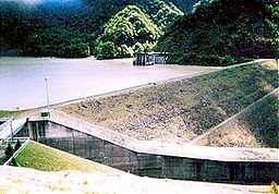
The Shizunai River flows generally southwest from its headwaters in the Hidaka mountains at the confluence of the Koikakushushibichari and Koibokushushibichari rivers. It flows into Lake Takami (高見湖, Takami-ko), a reservoir created by the Takami Dam. Past the dam, the Shizunai river flows into Shizunai Flood Control Reservoir (静内調整池, Shizunai Chōseichi). Past the Shizunai Dam, the river encounters Futa Dam before leaving the mountains for the flood plain. The river flows past the outlying communities of Shizunai before entering the Pacific Ocean just northwest of Shizunai harbor.
Natural history
The Shizunai River was designated as a wildlife protection area in 1965. Whooper swans overwinter on the Shizunai River.
History
The Shizunai River basin was the home of Shakushain the Ainu leader who led a revolt against the Japanese especially the Matsumae clan in the 1660s. In the Edo period the region was used for gold mining.
List of bridges and dams
From river mouth to source:
List of (named) tributaries
From river mouth to source:
- Left — Hidaka Mena River (日高目名川, Hidaka Mena Gawa)
- Right — Perari River
- Left — Mount Sumi River (炭山, Sumiyama Kawa) charcoal or coal mountain river
- Left — Shunbetsu River
- Right — Poyoppusawa River
- Right — Pisenaisawa River
- Left — Penkeonikemushi River
- Left — Ponpanbetsu Creek
- Left — Penkebetsusawa River
- Left — Porokaunnai River
- Right — Ibetsusawa River
- Right — Abeunnai River
- Confluence Left — Koibokushuchchari, Right — Koikakushuppichari