
Length 110 km | ||
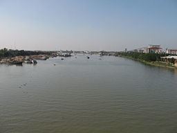 | ||
Shitalakshya river shitalokkha
Shitalakshya River (Bengali: শীতলক্ষ্যা নদী Shitalokkha Nodi) (also known as Lakhya River) is a distributary of the Brahmaputra. In its initial stages it flows in a southwest direction and then east of the city of Narayanganj in central Bangladesh until it merges with the Dhaleswari near Kalagachhiya. A portion of its upper course is known as Banar River. The river is about 110 kilometres (68 mi) long and at it widest, near Narayanganj, it is 300 metres (980 ft) across. Its flow, measured at Demra, has reached 74 cubic metres per second (2,600 cu ft/s). It remains navigable year round. The river flows through Gazipur district forming its border with Narsingdi for some distance and then through Narayanganj District.
Contents
- Shitalakshya river shitalokkha
- Map of Shitalakshya River Bangladesh
- Road to barodi shitalakshya river
- Change in course of rivers
- Historical importance
- Economic importance
- References
Map of Shitalakshya River, Bangladesh
The river's maximum depth is 21 metres (70 ft) and average depth is 10 metres (33 ft).
Road to barodi shitalakshya river
Change in course of rivers
The Shitalakhya is a branch of the Brahmaputra which has changed its course at least twice in the Bangladesh region in the fairly recent past, indirectly affecting the flow of water in the Shitalakhya. In the 21st century, the main flow of the Brahmaputra waters is through the Jamuna channel. Earlier, after tracing a curve round the Garo Hills on the west, it took a sharp turn in the south-east direction near Dewanganj, and then passing by Jamalpur and Mymensingh, threw off the Shitalakhya branch and flowed through the eastern part of Dhaka district and fell into the Dhaleshwari. The Shitalakhya ran almost parallel to the Brahmaputra and after passing by Narayanganj joined the Dhaleswari. The course of the Brahmaputra through Dhaka district was deserted by the 18th century when it flowed further east and joined the Meghna near Bhairab. Towards the end of the 18th century the Jamuna channel increased its importance and around 1850 it became the main channel of the Brahmaputra.
In Van den Brouck's map the river is marked as Lecki, flowing west of Barrempooter (Brahmaputra). In Van den Brouck’s time (1660), it was large and swift flowing river. It was so till the early 19th century. There, however, are some reservations about the accuracy of Van den Brouck’s map.
Historical importance
Sonargaon, a former capital of the region, stood on the banks of the Shitalakhhya. A fort was built by Isa Khan, a former ruler of the area, on its banks. It is believed that it was connected with Lalbagh Fort in Dhaka through an underground tunnel. Sonakanda Fort, also on the river, was built to counter Magh and Portuguese pirates. There are several historical mosques on its banks – Bandarshahi mosque (built in 1481 by Baba Saleh), Kadam Rasul mosque (containing the footprints of Hazrat Mohammad), Mariamer masjid (built by Shaista Khan) etc.
Economic importance
The Shitalakshya River was once an important center for the muslin industry. Even today, there are centres of artistic weaving on its banks. There also are a number of industrial units on its banks, including the Adamjee Jute Mills. Thermal power houses are located along the river at Palash (north of Ghorashal) and at Siddhirganj. Industrial affluent dumped into the river resulting in high levels of pollution is a cause for concern.
There is a river port in Narayanganj. Numerous launches move out along the river to different parts of Bangladesh. The government has approved construction of a container terminal on the river Shitalakhya with foreign investment.