
Elevation 4.9 m Zip code 99772 | State Alaska Incorporated July 13, 1969 Area code 907 Population 582 (2013) Local time Saturday 1:32 PM | |
 | ||
Weather -18°C, Wind W at 11 km/h, 72% Humidity | ||
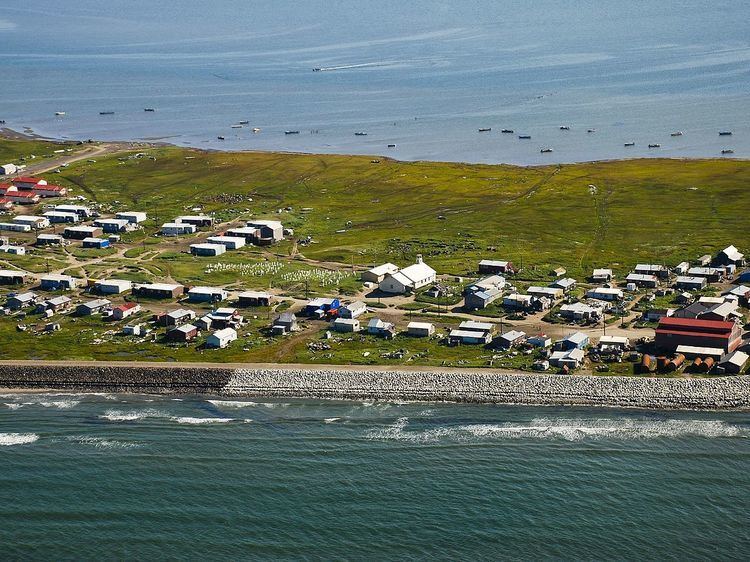
Shishmaref (SHISH-muh-reff) (Qiġiqtaq in Iñupiaq; Russian: Шишмарёв) is a city in the Nome Census Area, Alaska, United States. It is located on Sarichef Island in the Chukchi Sea, just north of the Bering Strait and five miles from the mainland. Shishmaref lies within the Bering Land Bridge National Preserve. The population was 563 at the 2010 census.
Contents
- Map of Shishmaref AK USA
- Geography
- Global warming
- Culture
- Demographics
- Education
- Transportation
- Housing
- Government
- Business
- Services
- References
Map of Shishmaref, AK, USA
Geography
According to the United States Census Bureau, the city has a total area of 7.3 square miles (19 km2), of which, 2.8 square miles (7.3 km2) of it is land and 4.5 square miles (12 km2) of it (61.62%) is water.
Shishmaref was named in 1821 by explorer Lt. Otto von Kotzebue, of the Imperial Russian Navy, after Capt. Lt. Gleb Shishmaryov who accompanied him on his exploration.
Sarichef Island (on which Shishmaref is located) is part of a dynamic, 100 km-long barrier island chain that records human and environmental history spanning the past 2000 years; the oldest subaerial evidence for the formation of this system is about 1700 years before present, according to carbon 14 dating (see References, below). Erosion at Shishmaref is unique along the islands because of its fetch exposure and high tidal prism, relatively intense infrastructure development during the 20th century, and multiple shoreline defense structures built beginning in the 1970s.
Global warming
The effect of global climate change upon Shishmaref is sometimes seen as the most dramatic in the world. Rising temperatures have resulted in a reduction in the sea ice which serves to buffer Shishmaref from storm surges. At the same time, the permafrost that the village is built on has also begun to melt, making the shore even more vulnerable to erosion. In recent years the shore has been receding at an average rate of up to 10 feet (3.3 m) per year. Although a series of barricades has been put up to protect the village, the shore has continued to erode at an alarming rate. The town's homes, water system and infrastructure are being undermined. Currently, Shishmaref has obtained funds to construct seawalls that protect some of the shoreline.
The village had plans to relocate several miles to the south, on the mainland to the Tin Creek site. However, Tin Creek proved unsuitable for long term settlement due to melting permafrost in the area. The Shishmaref Erosion and Relocation Coalition, made up of the city, the IRA Council and other organizations, is seeking federal, state and private funding for a move elsewhere. The cost of moving Shishmaref is estimated at $180 million, nearly $320,000 per resident. The village was told by the Obama administration that no federal money was available, therefore tensions arose in 2013 when John Kerry announced Vietnam would receive $17 million to deal with climate change.
Erosion rates along the island front exceed (and are not comparable with) those along adjacent sectors. Erosion is occurring along the entire island chain, but it is exacerbated at Sarichef Island in part because of the hydrographic impacts of hard armoring of a sandy shoreface and permafrost degradation that is accelerated by infrastructure. Residents are experiencing the effects of coastal retreat on residential and commercial properties.
On August 16, 2016, the village voted to move the town to the mainland.
Culture
Shishmaref is a traditional Inupiaq Eskimo village. Residents rely heavily on a subsistence lifestyle, hunting and gathering much of their food. Primary food sources include sea mammals such as oogruk (bearded seal), other seals and walrus, fish, birds (such as ptarmigan), caribou and moose. The village is well known in the region for its high-quality seal oil and fermented meat.
It is known for its Native art. Local carvings of whalebone and walrus ivory are sought after by galleries in Alaska and the Lower 48.
Shishmaref was home to one of Alaska's most-beloved dog mushers. Herbie Nayokpuk, known as the "Shishmaref Cannonball", died in December 2006. He finished the Iditarod Trail Sled Dog Race numerous times, including a second-place finish.
It is sometimes referred to as "the friendliest village in Alaska." Researchers, journalists and the occasional tourist visit Shishmaref, and the city has acquired a reputation for being a gracious host.
Demographics
As of the census of 2000, there were 562 people, 142 households, and 110 families residing in the city. The population density was 202.0 people per square mile (78.1/km²). There were 148 housing units at an average density of 53.2 per square mile (20.6/km²). The racial makeup of the city was 5.34% White, 93.24% Native American (mainly Inupiat), and 1.42% from two or more races. Hispanic or Latino of any race were 0.53% of the population.
There were 142 households out of which 52.8% had children under the age of 18 living with them, 36.6% were married couples living together, 19.7% had a female householder with no husband present, and 22.5% were non-families. 21.1% of all households were made up of individuals and 4.2% had someone living alone who was 65 years of age or older. The average household size was 3.96 and the average family size was 4.59.
In the city, the population was spread out with 40.9% under the age of 18, 11.4% from 18 to 24, 29.4% from 25 to 44, 12.6% from 45 to 64, and 5.7% who were 65 years of age or older. The median age was 24 years. For every 100 females there were 125.7 males. For every 100 females age 18 and over, there were 121.3 males.
The median income for a household in the city was $30,714, and the median income for a family was $29,306. Males had a median income of $35,357 versus $25,000 for females. The per capita income for the city was $10,487. About 16.2% of families and 16.3% of the population were below the poverty line, including 21.2% of those under age 18 and 10.5% of those age 65 or over.
Education
Shishmaref is served by the Bering Strait School District. Shishmaref School is the only school in town and serves grades Pre-K through 12 with a population of 183 students and 33 pre-school children. There are 19 teachers at Shishmaref School and is the largest and newest building in settlement.
Transportation
There are three main roads, Main Street-Airport Road, Housing Trail and Clinic Road. Roads are not paved but have street lighting and do not connect to the outside beyond Shishmaref. Vehicles are mostly ATVs with a few private vehicles and dirt motorcycles.
Some residence will travel by wood vessels around Sarichef Island and a barge delivers goods and materials to Shishmaref when it is ice free.
Shishmaref Airport is the only means of connecting the town to the rest of Alaska. The airport replaced an earlier airport which is now occupied by housing near the lagoon.
Housing
Houses in Shishmaref are pre-fabricated and mostly single story. Construction material is mostly wood board and sometimes metal. The homes are often damaged from erosion.
Government
Business
Services
Services
There are two health clinics in Shishmaref providing basic care:
Policing is provided by Shishmaref Police Department and fire services are provided by Shishmaref Volunteer Fire Department.