
Population 3,180 (1992) Area 919.2 km² Council seat Wangaratta | Established 1863 Founded 1863 | |
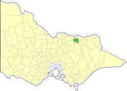 | ||
The Shire of Wangaratta was a local government area about 260 kilometres (162 mi) northeast of Melbourne, the state capital of Victoria, Australia. The shire covered an area of 919.24 square kilometres (354.9 sq mi), and existed from 1863 until 1994. The Shire did not include Wangaratta itself, which was governed by a separate local government.
Contents
History
Wangaratta was first incorporated as the North Ovens Road District on 10 June 1863, which became a shire on 17 September 1867. Part of the Mokoan Riding of the Shire of Benalla was annexed as the Killawarra Riding on 31 May 1906. The shire was renamed Wangaratta on 22 November 1916.
On 18 November 1994, the Shire was abolished, and merged with the City of Wangaratta, the Shire of Oxley and various surrounding districts into the Rural City of Wangaratta.
Wards
Wangaratta was divided into four ridings, each of which elected three councillors:
Towns and localities
Population
* Estimate in the 1958 Victorian Year Book.