
Country Tanzania Capital Shinyanga Postcode 37xxx Area 18,901 km² Area code 028 | Zone Lake Time zone EAT (UTC+3) Website shinyanga.go.tz Population 1.535 million (2012) | |
 | ||
Points of interest Serengeti, Serengeti National Park, Ngorongoro Conservation Area, Moru Kopjes, Mbalageti Tented Camp | ||
Shinyanga Region is one of Tanzania's 30 administrative regions. The regional capital is the municipality of Shinyanga. According to the 2012 national census, the region had a population of 1,534,808. For 2002-2012, the region's 2.1 percent average annual population growth rate was the twentieth highest in the country. It was also the tenth most densely populated region with 81 people per square kilometer. With a size of 50,781 square kilometres (19,607 sq mi), the region is slightly smaller than Costa Rica (51,100 square kilometres (19,700 sq mi)).
Contents
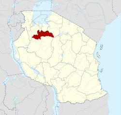
Map of Shinyanga Region, Tanzania
The region is bordered to the north by the Mwanza, Mara, and Kagera Regions and to the south by the Tabora Region. Kigoma Region borders to the west, Singida Region to the southeast, and the Arusha and Manyara Regions to the east.
Districts
As of 2012, the region is administratively divided into five districts:
Culture
The predominant tribes of the Shinyanga region are the Sukuma, Nyamwezi, and Sumbwa tribes.
Economy
Traditional agriculture in the area varies, but it is often maize, cotton, and rice production.