
Elevation 5,091 m | Range Himalayas | |
 | ||
Location Jammu and Kashmir, India Similar Phugtal Monastery, Pensi La, Gumbok Rangan, Lamayuru Monastery, Sasser Pass | ||
Shinku la shinko la shingo la darcha to zanskar new motorable pass
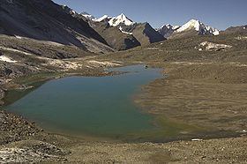
Shingo-la is a mountain pass in India, on the border between Jammu and Kashmir and Himachal Pradesh. There is a shallow lake or pool 20m below the pass. The pass is on a long-distance footpath linking Zanskar and Lahaul, used often by locals and trekkers alike. For trekkers it is one of the technically easiest 5000m passes in Indian Himalaya, involving no glacier trekking nor steep climbs. There is snow on the pass all year round, although in the summer only a small stretch of snow has to be passed. There is no official sign proclaiming height of the pass. The height indicated by various trekking website varies from 4900 to 5100 meters.
Contents
- Shinku la shinko la shingo la darcha to zanskar new motorable pass
- Map of Shingo La Himachal Pradesh 175142
- References
Map of Shingo La, Himachal Pradesh 175142
This pass may be considered as an entry point to Lugnak Valley in Zanskar. The nearest inhabited village on Zanskar side is Kurgiak and on the Lahaul side is Chikka. Both the villages generally involves two days trekking from the pass. The base camp for crossing the pass are set up at Chumik Nakpo from Darcha side and Lakham from Padum side.
The Indian government is planning to build a road over Shingo La. Currently there is no road going south from Zanskar. However, there is an unmetalled road till Zanskar Sumdo which is 9-10 hrs from this pass towards Darcha side. The four-wheelers however can come till Palamo which is around 8 km from Zanskar Sumdo towards Darcha side.
August 2016, the road now extends all the way to Shingo La, with plans for it to continue up the Zanskar Valley over the next two to four years.