
Country Japan - Flower Tea Area 179.7 km² | Phone number 0599-44-0001 Population 53,056 (Sep 2012) Local time Saturday 10:53 PM | |
 | ||
Weather 6°C, Wind NW at 6 km/h, 83% Humidity Points of interest Parque Espana‑Shima Spain Vill, Shima Marineland, Izawa‑no‑miya Shrine, Hotel Shima Spain Mu, Tomoyama Park | ||
Shima (志摩市, Shima-shi) is a city in Mie Prefecture, Japan.
Contents
- Map of Shima Mie Prefecture Japan
- Geography
- Neighboring municipalities
- History
- Rail
- Highways
- Local attractions
- References
Map of Shima, Mie Prefecture, Japan
As of September 2012, the city has an estimated population of 53,056 and a population density of 295 persons per km². The total area is 179.67 km².
Shima hosted the 2016 G7 Summit.
Geography
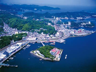
Shima is located on the southern half of Shima Peninsula in far eastern Mie Prefecture, facing Ise Bay of the Pacific Ocean. The city has two inlets: Matoya Bay and Ago Bay. Matoya Bay is famous for oyster cultivation and Ago Bay is famous for pearl cultivation. Both are sightseeing spots and most of the city is within the borders of the Ise-Shima National Park.
Shima has three inhabited islands; Watakano Island, Kashiko Island and Masaki Island. Watakano Island is located in Matoya Bay, and the others are in Ago Bay.
Neighboring municipalities
History
The modern city of Shima was established on October 1, 2004, from the merger of the former town of Shima, absorbing the towns of Ago, Daiō, Hamajima and Isobe (all from Shima District). Recently there has been anger from its famous divers aimed at its sexist new tourist mascot.