
District Sakhalin District Sakhalin Total islands 1 Island group Kuril Islands | Archipelago Kuril Islands Capital city Tokyo Area 255 km² Population 2100 | |
 | ||
Highest point Mount Tomari; 412 metres (1,352 ft) | ||
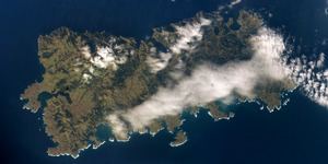
Shikotan (Russian: Шикотан; Japanese: 色丹島 (Shikotan) ; Ainu: シコタン or シコタヌ, Sikotan), also known as Shpanberg (after Martin Spangberg), is an island which is administered by the Russian Federation as part of Yuzhno-Kurilsky District of Sakhalin Oblast, and that is claimed by Japan as part of Nemuro Subprefecture of Hokkaido Prefecture. It is one of the islands (along with the Habomai Islands) which the Soviet Union agreed in 1956 to transfer to Japan in the event of a peace treaty between the two countries (such a peace treaty has never been concluded). The name of Shikotan derives from the Ainu language and means "the village proper" or "real town".
Contents
Map of Shikotan-to, 694521
The total land area of Shikotan is 225 km². The island is hilly, averaging 300 metres in elevation. The shores of the island are very indented and covered with oceanic meadows. The highest altitude is 412 m. The island is formed by the volcanic rock and sandstone of the Upper Cretaceous and Cenozoic periods. There are two extinct volcanoes on Shikotan: Mount Tomari and Mount Notoro.
Shikotan's vegetation consists mostly of Sakhalin fir, larch, deciduous trees, bamboo underbrush, and juniper brushwood.
There are two settlements: Malokurilskoye (formerly Shikotan or Shakotan) and Krabozavodskoye (formerly Anama).
The primary economic activities are fisheries and fishing, with the principal marine products being cod, crab, and kelp.
An earthquake and subsequent tsunami caused major damage on the island's coastline on October 4, 1994.
In Popular Culture
The 2014 anime film Giovanni's Island is a fictionalized account of the fate of Japanese civilians living on Shikotan at the time of the 1945 Soviet occupation.