
Province Khyber Pakhtunkhwa | ||
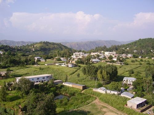 | ||
Sherwan is a Union council of Abbottabad District in Khyber-Pakhtunkhwa province of Pakistan, located 35 km west of Abbottabad.Sherwan.—A village, or rather a couple of villages almost adjoining each other,' and known, the northern as Sherwan Kalan, and the southern as Sherwan Khurd, on a ridge some 5,000 feet high in the centre of Lower Tanawal Sherwan is located in a beautiful valley which is surrounded by large, forested mountains on three sides. These forests host a number of wild animals, such as jackals, wolves, pigs, porcupines, fox and occasionally leopards.Sherwan is divided into two parts Sherwan Khurd (small) and Sherwan Kalan (wide). Sherwan Kalan covers a much larger area than Sherwan Khurd. In the North-East of Sherwan Union Council there is another village called Patheel. On the south of the valley there is a stream called Mangal, home to a number of fish such as Trout,eels and soles etc.
Contents
- Map of Sherwan Pakistan
- Location and demographics
- Education and literacy
- Sherwan Under The Rule Of Turks
- Sherwan Under The Rule Of Sikhs
- Sherwan under British rule
- Fort Of Sherwan
- Economy
- References
Map of Sherwan, Pakistan
Location and demographics
Sherwan is 5,000 ft high in the centre of Tanawal. The population of main Sherwan village, or villages complex, is over 25000. The local language is Hindko while Urdu is also understood and spoken by local people.The Tanawal was divided into to parts Upper Tanawal and Lower Tanawal. Sherwan is located in Lower Tanawal.The main tribes of Sherwan are Tanolis (Alishal,Saidal,Bagal,Labial, Sarganal and Sadial), Awans, Syeds and Mughals.
Education and literacy
The literacy rate of Sherwan is high compared to other villages of the area. There are a lot of Government schools and colleges in Sherwan:
Sherwan Under The Rule Of Turks
Tanawal was also a part of Pakhli, which was ruled by Turks for centuries. Sherwan was the capital of lower Tanawal under Turks.The last Turkish Wali (Governor) was Qias-ud-din during the 3rd quarter of 18th century
Sherwan Under The Rule Of Sikhs
After doing away with Sardar Muhammad Khan Tarin and Bostan Khan Tarin and others in lower Hazara, the Sikhs had a field day in tormenting and persecuting the population. The Mashwanis of Srikot were forced to migrate from their homelands and because of this they were refugees in nearby localities for six to seven years. Many of them crossed the Indus and moved to Swabi. The Sikhs also forcefully conscripted several Mashwani youths in their army. After the death of Maharaja Ranjit Singh, the Sikh empire fell prey to disorder and hence their rule weakened.
In 1849, the Sikhs were finally defeated by the British and the area came under the British jurisdiction, of the Hazara district.
Sherwan under British rule
The British ruled this region mostly through the local chiefs. Nawab Khan Tanaoli and his allies conquered Sherwan Fort, Sherwan and nearby villages and continued ruling Sherwan.
Fort Of Sherwan
Sherwan Fort in Sherwan was built by the Sikhs in 1822 A.D. It was stormed and conquered by Nawab Khan Tanaoli. Later Major James Abbott built inside of it in a Victorian style,this national heritage got auctioned, on May 24, 2007.This fort was mentioned by Sir General James Abbott in his diaries who was one of the builders of British Empire.
Economy
Locals grow seasonal grain crops such as maize and wheat. The area of Sherwan has plenty of water and soil rich with nutrients, allowing producers to grow Cherries, Plums, Apples, Pears and Apricots.The mountains of Sherwan are full of minerals like top quality Soap stone. The largest soapstone deposits of the country are located near Sherwan in Hazara. The steatite at this location is of excellent quality.A huge deposit of Soap stone is found in the mountains of a nearby village. A large number of people are also engaged in soap stone mining.The most extensive steatite deposits in Pakistan are found in the Sherwan area of the Hazara District, NWFP. Iron Ore, Lead, magnesite ore are also found in these mountains.