
Mean depth 40 m Width 1.8 km | Average depth 40 metres (130 ft) Surface elevation 4,142 m Length 2.3 km | |
 | ||
Max. length 2.3 kilometres (1.4 mi) Max. width 1.8 kilometres (1.1 mi) | ||
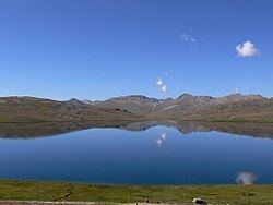
Sheosar Lake (Urdu: شاؤسر جھیل) (also called Shausar Lake) is a lake situated in Deosai National Park, in Gilgit-Baltistan province of northern Pakistan.
Contents
- Map of Shausar Lake
- Meanings in Local Language Shina
- Routes to the Lake
- Skardu Route
- Astore Route
- Best Time to Visit
- References
Map of Shausar Lake
The lake is at an elevation of 4,142 metres (13,589 ft) in the Karakoram-West Tibetan Plateau alpine steppe. Its approximate length is 2.3 kilometres (1.4 mi), width 1.8 kilometres (1.1 mi), and average depth is 40 metres (130 ft).
Meanings in Local Language (Shina)
Sheosar Lake means 'Blind Lake', as 'Sheo' in Shina Language means 'Blind' and 'Sar' means 'Lake'.
Routes to the Lake
The lake is accessible through two routes. One is via Skardu and the other via Astore District.
Skardu Route
The road through Skardu can be covered by jeep in few hours, however, if trekked, it can take 2 days time.
Astore Route
Second route is from Astore District. From main Astore town, it takes about 4 hours' jeep travel through a semi-metal road to reach Chilim, the last residential area adjacent to the plains.
Best Time to Visit
Between the months of November to May the whole area of Deosai is snow bound. However, the area has much natural beauty during Spring and Summer Season. During spring, the whole surrounding gets covered with wide variety of colorful flowers and butterflies. The best time of visiting this beautiful lake is in summer between June to early September.