
Coat of arms Flag Town Shatura Local time Saturday 12:31 AM | Area 36 km² | |
 | ||
Weather 1°C, Wind SW at 8 km/h, 86% Humidity | ||
Shatura (Russian: Шату́ра) is a town and the administrative center of Shatursky District in Moscow Oblast, Russia, located on Lake Svyatoye 124 kilometers (77 mi) east of Moscow. Population: 32,885 (2010 Census); 30,393 (2002 Census); 31,635 (1989 Census).
Contents
Map of Shatura, Moskovsky, Russia, 140700
History
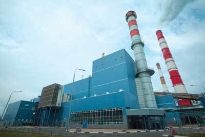
A settlement on the site of modern Shatura has existed since 1423. In 1917, peat deposits mining started in the vicinity. In 1918, construction of the first peat-fueled electric Shatura Power Station began near the village of Torbeyevka (Торбе́евка). In 1919, the settlement of Shaturstroy (Шатурстро́й) was founded nearby and in 1920, the settlement of Chyornoye Ozero (Чёрное О́зеро) followed. In 1928, the three settlements were merged to form the settlement of Shatura, which was granted town status in 1936.
Administrative and municipal status
Within the framework of administrative divisions, Shatura serves as the administrative center of Shatursky District. As an administrative division, it is, together with twenty-three rural localities, incorporated within Shatursky District as the Town of Shatura. As a municipal division, the Town of Shatura is incorporated within Shatursky Municipal District as Shatura Urban Settlement.
Sports
Shatura is home to bandy club Energiya.