
Location Almaty, Kazakhstan Watercourses Sharyn River Phone +7 747 706 2357 | Long-axis length 80 kilometres (50 mi) Address Kazakhstan Watercourse Sharyn River | |
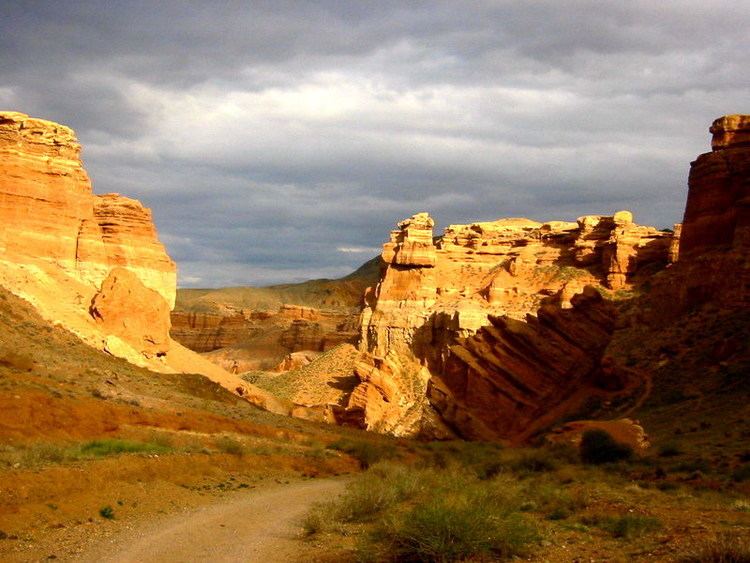 | ||
Road trip from almaty kazakhstan to sharyn canyon part 2
Sharyn Canyon (also known as Charyn Canyon) is a canyon on the Sharyn River in Kazakhstan, 200 kilometres (120 mi) east of Almaty, close to the Chinese border. The canyon is 80 or 90 kilometres (50 or 56 mi) in length. It is within the Sharyn River valley and is part of the Sharyn National Park, which was established on 23 February 2004, and is located within the territory of the Uygur District, Raiymbek District and Enbekshikazakh District of the Almaty Province. Over several millennia of weathering action, the canyon has gained colorful formations of varying shapes and sizes. Though it is much smaller than the Grand Canyon, it has been described as being equally impressive.
Contents
One part of the canyon is known as Valley of Castles (Dolina Zamkov) for its unusual rock formations, and its length is 3 kilometres (1.9 mi) with a depth of 100 metres (330 ft).
Etymology
Some scholars think that the name of the river is derived from the Uyghur word 'Sharyn' meaning "ash tree". There is also another interpretation that it is a derivative of the Turkic root word 'Char', which means a "precipice". Both these interpretations fit the site conditions where the terrain is precipitous, and ash trees are found.
Features
The canyon formation is along the banks of the fast flowing Charyn River in a northern flow stretch of about 80 kilometres (50 mi) (90 kilometres (56 mi) is also stated) which is a tributary of the Ile River; the river has a total length of 393 kilometres (244 mi). The river rises from the Tian Shan Mountains (meaning: "Heavenly Mountains",) that is spread over the arid semi-desert to the east of Almaty. In parts, it attains a depth of 150 to 300 metres (490 to 980 ft). The geological formation of the canyon is of sedimentary red sandstone which have been subject to the "atmogenic process" (defined in Websters dictionary as "atmospheric origin by condensation, wind action, or deposition from volcanic vapors") of water and wind erosion resulting in "weird and colourful formations" in the form of sculptures.
Access to the canyon is from Almaty on the main road towards east which passes through small villages called Chilik, Baiseit, and Kokpek, at a distance of about 190 kilometres (120 mi). From here, a signposted road leads to the parking area of the canyon over a distance of 9 kilometres (5.6 mi), and passes through the Sharyn (or Charyn) National Park. From the parking area a track leads to the canyon. Another path from the park, which is 1 kilometre (0.62 mi) in length, leads to an area where views of the canyon are more scenic. Adventure sports activities in the river are white-water rafting and canoeing. Fishing is done on the river for the local species of fish called "Naked Osman". Further downstream of the canyon is a dry zone of the gorge called the Red canyon or "Valley of Castles" which stretches over a length of about a km and has a depth of about 100 metres (330 ft). There is a track at the vale of this gorge which has naturally sculpted red stone formations.
About 20 kilometres (12 mi) away from the canyon is the remnant of a relic forest. This forest, under the umbrage of the canyon. is known as the "Sogdian ash" (Ash Tree), a tree which is said to be a derivative from the Ice age, and is one of the forest formations which is unique in the world. It was declared a protected reserve in 1964. It is now integrated with the Charyn National Park. Apart from the Ash Tree, other species of trees reported from this forest are willow, poplar, and barberry. This area can be accessed from another road from Almaty which passes through Kokpek, Shonzy and Zharkent.