
Rural localities 52 Founded 1929 | Federal subject Republic of Dagestan Selsoviets 10 Area 892.2 km² | |
 | ||
Municipally incorporated as | ||
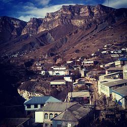
Shamilsky District (Russian: Шамильский райо́н) is an administrative and municipal district (raion), one of the forty-one in the Republic of Dagestan, Russia. It is located in the western central part of the republic. The area of the district is 920 square kilometers (360 sq mi). Its administrative center is the rural locality (a selo) of Khebda. As of the 2010 Census, the total population of the district was 28,122, with the population of Khebda accounting for 9.1% of that number.
Contents
- Map of Shamilsky District Dagestan Republic Russia
- History
- Administrative and municipal status
- References
Map of Shamilsky District, Dagestan Republic, Russia
History
Until 1994, the district was called Sovetsky (Сове́тский).
Administrative and municipal status
Within the framework of administrative divisions, Shamilsky District is one of the forty-one in the Republic of Dagestan. The district is divided into ten selsoviets which comprise fifty-two rural localities. As a municipal division, the district is incorporated as Shamilsky Municipal District. Its ten selsoviets are incorporated as twenty-five rural settlements within the municipal district. The selo of Khebda serves as the administrative center of both the administrative and municipal district.