
- location Shakotan, Hokkaidō | - elevation 1,255 m (4,117 ft) | |
 | ||
Municipalities Iwanai, Kyowa, Tomari, Kamoenai, Shakotan, Furubira, Yoichi | ||
hokkaido premier seafood sapporo shakotan peninsula japan
The Shakotan Peninsula (積丹半島, Shakotan hantō) in Shiribeshi, on the west coast of Hokkaidō, Japan, is a mountainous peninsula which projects some 30 kilometres (19 mi) into the Sea of Japan. The Shakotan Peninsula forms part of the Niseko-Shakotan-Otaru Kaigan Quasi-National Park.
Contents
- hokkaido premier seafood sapporo shakotan peninsula japan
- Map of Shakotan Peninsula Nozukacho Shakotan Shakotan District Hokkaido Prefecture 046 0325 Japan
- Shakotan peninsula blue water
- Geography
- Municipalities
- Economy
- References
Map of Shakotan Peninsula, Nozukacho, Shakotan, Shakotan District, Hokkaido Prefecture 046-0325, Japan
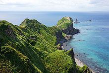
Shakotan peninsula blue water
Geography
The peninsula has a rugged terrain with few level areas. The coastline of the peninsula suffers from extensive marine erosion, which resulted in the numerous natural stone pillars which project from the sea. Mount Shakotan (1,255 metres (4,117 ft)) forms the highest peak on the peninsula. The peninsula has numerous scenic capes and inlets, notably Cape Shakotan and Cape Kamui.
Municipalities
The Shakotan Peninsula spans seven municipalities in Hokkaidō, all within Shiribeshi Subprefecture.
Economy
The area was once a thriving center of Pacific herring fishing, which was conducted from the villages of Furubira, Iwanai, and Yoichi.