
FIPS code 47-67460 Elevation 849 m Local time Thursday 11:35 PM | Time zone Eastern (EST) (UTC-5) GNIS feature ID 1301197 Zip code 37688 Area code 423 | |
 | ||
Weather 13°C, Wind E at 13 km/h, 82% Humidity | ||
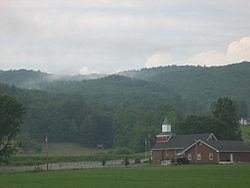
Shady Valley is an unincorporated community in Johnson County in the northeastern corner of the U.S. state of Tennessee. It is just outside Cherokee National Forest. Shady Valley is also the name of the valley in which the town is located, between Holston Mountain on the northwest, and the Iron Mountains to the southeast. At 2,785 feet, it is the second-highest community in Tennessee.
Contents
Map of Shady Valley, TN 37688, USA
Natural history
After the Pleistocene ice ages, species and ecosystems that had shifted southward often survived in local refugia. As a result, cold-adapted ecosystems, such as cranberry bogs, remain in Shady Valley, far south of their usual range. Shady Valley once contained an estimated 10,000 acres (40 km²) of boreal cranberry bogs.
Recreation
The roads that run in and around the town are popular among motorcyclists since nearby mountains provide nearly 500 curves to navigate. The most popular road for motorcyclists is US-421, which offers many challenging curves.
Economy
Shady Valley has one small general store, in addition to two other small businesses, a U.S. Post Office and the Shady Valley Elementary School.
The town holds its annual Cranberry Festival the second weekend in October with food, a parade and auctions.