
Opening date 1946 Height 19 m Catchment area 484.3 km² Construction began 1944 | Type of dam Zoned earth-fill Length 3,077 ft (938 m) Opened 1946 | |
 | ||
Spillway capacity 10,000 cu ft/s (280 m/s) Operator United States Bureau of Reclamation Similar | ||
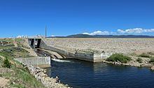
Shadow Mountain Dam is a zoned earth-fill dam on the Colorado River in Grand County, Colorado. Constructed between 1944 and 1946, the Shadow Mountain Dam creates the Shadow Mountain Lake, with a structural height of 63 feet (19 m) and a drainage area of 187 square miles (480 km2). Shadow Mountain Lake is a holding reservoir for water pumped up from Lake Granby just to the south through the Granby Pumping Plant and Canal. Shadow Mountain Lake is connected by a short channel to the natural Grand Lake. The west portal of the Alva B. Adams Tunnel is located on Grand Lake. The Adams Tunnel diverts west slope water to the east slope of the Rocky Mountains for use in agriculture and to serve the populated areas of Colorado, including Denver.
Map of Shadow Mountain Dam, Grand Lake, CO 80447, USA
References
Shadow Mountain Dam Wikipedia(Text) CC BY-SA