
Opening date 1950 Opened 1950 | Type of dam Earthfill Height 91 m Catchment area 805.5 km² Construction began 1941 | |
 | ||
Owner(s) United States Bureau of Reclamation Length Dam 861 ft (262 m), dikes 12,722 ft (3,878 m) Operator United States Bureau of Reclamation Similar Lake Granby, Grand Valley Diversion, Shadow Mountain Dam, Palo Verde Dam, Rocky Mountains | ||
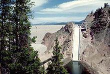
Granby Dam (National ID # CO01656) is an earthfill dam that dams the Colorado River 5.5 miles (8.9 km) northeast of Granby, Colorado in Grand County, Colorado. This 298-foot (91 m)-tall dam was constructed between 1941 and 1950 and has a drainage area of 311 square miles (810 km2). The Granby Dam's reservoir is known as Lake Granby, the largest reservoir component of the Colorado-Big Thompson Project. Lake Granby stores Colorado River water that is diverted under the Continental Divide for agriculture and municipal use within north-eastern Colorado including the cities of Boulder, Fort Collins, Loveland, and Greeley. In addition to the waters of the Colorado, water from Willow Creek just below the dam is pumped up 175 feet (53 m) to Lake Granby. Water from Lake Granby is pumped 125 feet (38 m) higher by the Granby Pumping Plant to the Granby Pump Canal, which extents 1.8 miles (2.9 km) to Shadow Mountain Lake, from which water is diverted through the Alva B. Adams Tunnel to the East Slope.
Map of Granby Dam, Granby, CO 80446, USA
This damsite does not generate any power directly; power is generated at other locations in the Colorado-Big Thompson Project.