
Country Hong Kong Constituencies 36 Area 69.4 km² | Region New Territories Time zone Hong Kong Time (UTC+8) Population 630,273 (2011) | |
 | ||
Website Sha Tin District Council Colleges and Universities Chinese University of Hong K, Hang Seng Management College, Immaculate Heart of Mary Coll Points of interest Hong Kong Heritage Museum, Ten Thousand Buddhas, Sha Tin Racecourse, Penfold Park, Art Museum of the Chine | ||
Sha Tin District (Chinese: 沙田區; Cantonese Yale: Sātìhn kēui) is one of the 18 districts of Hong Kong. As one of the 9 districts located in the New Territories, it covers the areas of Sha Tin, Tai Wai, Ma On Shan, Fo Tan, Siu Lek Yuen and Ma Liu Shui. The district is the most populous district in Hong Kong, with a population of 630,273.
Contents
- Map of Sha Tin District Hong Kong
- Pre colonial Era
- Colonial Era
- Land use
- Shing Mun River
- Transportation
- Hospitals
- Tourist attractions
- References
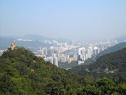
Map of Sha Tin District, Hong Kong
The Sha Tin District covers approximately 69.4 km² (26.8 sq. mi), including Sha Tin New Town and several country parks. Built mostly on reclaimed land in Sha Tin Hoi, the well-developed Sha Tin New Town comprises mainly residential areas along the banks of the Shing Mun River Channel. In the early 1970s it was a rural township of about 30,000 people. After Sha Tin's first public housing estate, Lek Yuen Estate, was completed in 1976, the settlement began to expand. Today, about 65% of the district's population live in public rental housing, housing under Hong Kong's Tenants Purchase Scheme, or Home Ownership Scheme.
Pre-colonial Era
Sha Tin was formerly named Lek Yuen, literally meaning the "source of trickling" or "source of clear water". The area of the present day Sha Tin was populated before the Ming Dynasty. As the Shing Mun River runs across the district, most local residents were farmers and relied on agriculture for living. In 1579, Tai Wai Village, the oldest and largest walled village in the district was built. Several other villages were built along the river after Tai Wai Village.
Colonial Era
Sha Tin started to be administered by the British Hong Kong government since the Convention for the Extension of Hong Kong Territory was signed. The establishment of the Sha Tin Station of the Kowloon-Canton Railway (British Section) in 1910 caused Sha Tin to be the more common name for the area, replacing Lek Yuen ever since.
Sha Tin was a former market town at the present location of Sha Tin Centre Street and New Town Plaza shopping centre.
Sha Tin Town was the second batch of satellite towns, or new town, to be built in the New Territories, on land reclaimed from the sea.
Land use
In addition to the residential areas, there are four industrial areas for light industries: Tai Wai, Fo Tan, Siu Lek Yuen and Shek Mun.
The Chinese University of Hong Kong is also located in Sha Tin. People typically travel there via the MTR East Rail Line and get off at University station. A minibus service operates on campus.
Sha Tin is the location for Hong Kong's second equestrian racecourse (the first and most famous being Happy Valley Racecourse) which has a capacity of 85,000. This course hosted the equestrian events during the 2008 Summer Olympics. The Olympics were hosted by Beijing, but there was concern over proper quarantine and disease monitoring in the Chinese capital.
Penfold Park is located inside the racecourse and closed on race days. It is best accessed via the Fo Tan Station. Sha Tin Park is another major park located in Sha Tin.
Shing Mun River
The Shing Mun River is a 7 km long, 200m wide channel originating at the Shing Mun Reservoir (Tai Mo Shan catchment) that runs as a river from the Tai Wai area, through the Sha Tin town centre to Tolo Harbour. It has three main tributaries, namely Tai Wai Nullah, Fo Tan Nullah and Siu Lek Yuen Nullah. Along the Shing Mun River are high-rise residential, commercial and industrial buildings with numerous village type developments scattered around.
Transportation
Sha Tin District has the largest number of East Rail Line stations of any district in Hong Kong. It has five stations, namely Tai Wai, Sha Tin, Fo Tan, Racecourse and University. The Ma On Shan Line runs between Tai Wai, Che Kung Temple, Sha Tin Wai, City One, Shek Mun, Tai Shui Hang, Heng On, Ma On Shan, and Wu Kai Sha stations.
A network of cycle tracks throughout Sha Tin measures about 50 km long and is the longest cycle track network in Hong Kong.
Increasing population in the town has exerted pressure on the transportation. Several construction plans have been launched to cope with the demand. The construction of Route T7 linking Ma On Shan Road to Sai Sha Road started in January 2001 and completed in 2005. Route 8, connecting Cheung Sha Wan, Kowloon and Sha Tin, is scheduled for construction at the end of 2003 and will be completed at the end of 2007. The construction of the Ma On Shan Line (11.4 km long) began in December 2000 and was completed at the end of 2004.
Tai Po Road, Sha Lek Highway, Sha Tin Road, Lion Rock Tunnel, Sai Sha Road, Tate's Cairn Tunnel, Tolo Highway and Shing Mun Tunnels already serve the Sha Tin District.
Hospitals
There are four hospitals in Sha Tin District:
Tourist attractions
Local and tourist attractions in the Sha Tin area include, most famously, the Hong Kong Heritage Museum, which is Hong Kong's newest and largest museum. The Museum was opened on 16 December 2000 and includes 12 galleries, a café and museum shop. Other attractions include: