
Basin size 1,010 km (390 sq mi) Length 96 km | River system Shōnai River Discharge 28.21 m³/s Basin area 1,010 km² | |
 | ||
Main source Mount Yūdachi727 m (2,385 ft) Bridges Biwajima Bridge, Kanori Bridge | ||
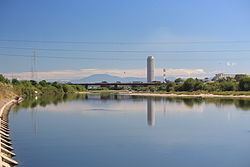
The Shōnai River (庄内川, Shōnai-gawa) is a Class 1 river flowing through Gifu and Aichi prefectures in Japan. In Gifu Prefecture, it is also referred to as the Toki River (土岐川 Toki-gawa); around the city of Kasugai in Aichi Prefecture, it is referred to as the Tamano River (玉野川 Tamano-gawa). Fujimae-higata (designated sites as List of Ramsar wetlands of international importance) exists in the River mouth.
Contents
Map of Shonai River, Aichi Prefecture, Japan
Geography
The river originates at Mount Yūdachi in Ena, Gifu Prefecture. After flowing through the Tamano Valley in Aichi Prefecture, it enters the Nōbi Plain, before emptying into Ise Bay through Nagoya's Minato-ku.
River communities
The river passes through or forms the boundary of the communities listed below.
References
Shōnai River Wikipedia(Text) CC BY-SA