
Native name وادي سيبوس Length 225 km | Basin size 6,471 km (2,498 sq mi) Country Algeria | |
 | ||
Discharge Average rate:11.5 m/s (410 cu ft/s) at Guelma and Annaba | ||
Seybouse (Arabic: وادي سيبوس Oued Seybouse) is a river in northeastern Algeria, near the border with Tunisia. In Roman times, it was called the Ubus.
Contents
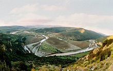
Map of Oued Seybouse, El Bouni, Algeria
Course
The river runs for about 225 kilometres (140 mi), flowing through Guelma and Annaba Provinces. It starts in Medjez Amar, in the Tell Atlas north-west of Guelma Province. Its flows into the Mediterranean Sea at Seybouse (called Joannonville under French rule) to the south-east of the city of Annaba. Its mouth is just north of Sidi Salem, the site of Hippo Regius where Saint Augustine lived in AD 391–430.
The Seybouse is used for irrigation of agricultural areas, but it is becoming polluted because of industrial activities.
References
Seybouse River Wikipedia(Text) CC BY-SA