
Basin countries Canada Average depth 1,500 ft (460 m) Area 26.2 km² Province British Columbia | Surface area 26.2 km (10.1 sq mi) Surface elevation 243 m Mean depth 457 m Cities Lillooet, Shalalth | |
 | ||
Type natural lake, reservoir Primary outflows Cayoosh Creek, Fraser River Settlements Lillooet, Seton Portage, Shalalth Outflow location Fraser River, Cayoosh Creek | ||
Seton lake reservoir bc hydro campground lillooet bc
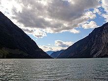
Seton Lake is a freshwater fjord draining east via the Seton River into the Fraser River at the town of Lillooet, British Columbia, about 22 km long and 243 m in elevation and 26.2 square kilometres in area. Its depth is 1500 feet.
Contents
- Seton lake reservoir bc hydro campground lillooet bc
- Map of Seton Lake British Columbia Canada
- Seton lake naxwit picnic spot in january 2015
- References
Map of Seton Lake, British Columbia, Canada
The lake is natural in origin but was raised slightly as part of the Bridge River Power Project, the two main powerhouses of which are on the north shore of the upper end of the lake near Shalalth. At the uppermost end of the lake is the community of Seton Portage and the mouth of the short Seton Portage River, which connects Anderson Lake on the farther side of the Portage to Seton Lake.
The Seton Portage River is the main source of natural inflow to Seton Lake, and is primarily fed by Anderson Lake but also by Whitecap Creek, which has its origin on the east slopes of Whitecap Mountain, the highest in the Bendor Range, and by Spider Creek, which has its origin on the north slopes of an unnamed summit to the south of Seton Lake, which happens to be the highest of the Cayoosh Range which lines the south flank of the valley.
The Canadian National Railway (formerly the British Columbia Railway, originally the Pacific Great Eastern) runs along the north shore of the lake.
Prior to the construction of the power project, Seton was considered the bluer and clearer and more brilliant of the two lakes. Afterwards, diversion of the glacial silt-laden waters of the Bridge River into Seton Lake have transformed it into a dull turquoise, and Anderson is now considered the bluer of the two lakes.
The lake was named in the 1860s by Alexander Caulfield Anderson, who traversed the uncharted territory in 1846, after his cousin and boyhood friend, Lt. Col. Alexander Seton, who was drowned in the wreck of the troopship HMS Birkenhead off the South African coast in 1852. In 1858 the route of the Douglas Road incorporated the lake passage.