
Peak Muixacre Width 3 km (1.9 mi) NNE/SSW Highest point Muixacre Mountains Talaió, Muixacre | Length 14 km (8.7 mi) WNW/ESE Elevation 1,275 m Province Province of Castellón Type of rock Karst | |
 | ||
Parent range Iberian System, eastern end Similar Serra del Turmell, Montegordo, Sistema Ibérico, Sierra de Santa Cruz - Ara, Muntanya de Santa Bàrbara | ||
Serra de Vallivana ([ˈsɛra ðe vaʎiˈvana], Spanish: Sierra de Vallivana) or Muntanyes de Vallivana is an over 14 km (9 mi) long mountain range straddling the Alt Maestrat and Baix Maestrat comarcas, Valencian Community, Spain.
Contents
Map of Serra de Vallivana, 12513, Castell%C3%B3n, Spain
GeographyEdit
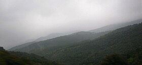
The highest point of the range is the 1,275 m high Muixacre, located close to the Port de Querol mountain pass in the N-232 road. Other important peaks are Montserrat and Talaió. These mountains are frequently covered in snow in the winter.
This mountain chain rises between the almost abandoned village of Vallivana and the top of the Maestrat mountains, south of the Serra del Turmell and west of the Serra de l'Espadella ranges. These mountains are named after the virgin of Vallivana, the patroness of Morella. The easiest route to reach the range is from Vallivana or from Morella
EcologyEdit
This sparsely-populated mountain area has the most important forested zone of the region with large prey birds such as the griffon vulture and wild animals like Spanish ibex, roe deer and wild boar.
The area of this range together with the neighboring Tinença de Benifassà and Serra del Turmell was declared a Site of Community Importance by the European Union under the name Tinença de Benifassà, Turmell i Vallivana.