
Elevation 1,163 m Highest point Roca Corbatera | Province Province of Tarragona | |
 | ||
Mountains Piló dels Senyalets, Roca Corbatera, La Cogulla Similar Cartuja de Escaladei, Prades Mountains, Priorat DOQ, Pantano De Siurana, Sant Bartomeu de Fragu | ||
Ultra trail serra de montsant 2012 mov
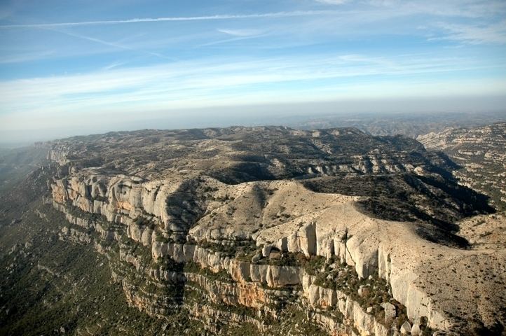
Serra de Montsant is a mountain chain in Catalonia, Spain. The main populated area in the range is La Morera de Montsant.
Contents
- Ultra trail serra de montsant 2012 mov
- Map of Serra de Montsant 43371 Tarragona Spain
- Ultra trail serra de montsant 2013 utsm
- Description
- Local wine
- References
Map of Serra de Montsant, 43371, Tarragona, Spain
Ultra trail serra de montsant 2013 utsm
Description
It is part of the Catalan Pre-Coastal Range. The main peaks are Roca Corbatera (1,163 m), Piló dels Senyalets (1,109 m) and la Cogulla (1,063 m). The Serra de Montsant, meaning 'Holy Mountain Range' is thus named because there were many hermits living in the range in early Medieval times.
The Montsant mountain range is currently a protected area, the Serra de Montsant Natural Park.
Local wine
This mountain region is a famous red wine-producing zone; some of the best vineyards are located near the Cartoixa d'Escaladei, a Carthusian Order monastery. It gives its name to the Montsant wine-producing area.
References
Serra de Montsant Wikipedia(Text) CC BY-SA