
Country United States Construction began 1969–80 Reactor type Pressurized water reactor | Status Operational Phone +1 423-843-8142 | |
 | ||
Location Hamilton County, near Soddy-Daisy, Tennessee Commission date Unit 1: July 1, 1981
Unit 2: June 1, 1982 Operator(s) Tennessee Valley Authority Address 2440 Igou Ferry Road, Soddy-Daisy, TN 37379, USA Reactor supplier Westinghouse Electric Company Similar Watts Bar Nuclear Generatin, Browns Ferry Nuclear P, Catawba Nuclear Station, Prairie Island Nuclear P, Beaver Valley Nuclear | ||
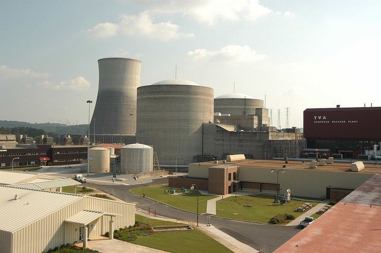
The Sequoyah Nuclear Plant is a nuclear power plant located on 525 acres (212 ha) located 7 miles (11 km) east of Soddy-Daisy, Tennessee, and 20 miles (32 km) north of Chattanooga, abutting Chickamauga Lake, on the Tennessee River. The facility is owned and operated by the Tennessee Valley Authority (TVA).
Contents
The plant has two Westinghouse pressurized water reactors. Sequoyah units 1 & 2, as well as their sister plant at Watts Bar, both have ice condenser containment systems. In case of a large loss-of-coolant accident, steam generated by the leak is directed toward borated ice which helps condense the steam creating a lower pressure, allowing for a smaller containment building.
Sequoyah's two units have a winter net dependable capacity of 2,333 megawatts, making Sequoyah the most productive of TVA's four nuclear plants. Sequoyah is the second-most powerful electric plant in the entire TVA system, second only to the Cumberland coal-fired plant northwest of Nashville. Following the restart of Brown's Ferry Unit 1, that plant again became most productive at 3,440 MW.
The operating license of Sequoyah's Unit 1 was originally set to expire in 2020, and Unit 2's operating license in 2021. In 2015, the NRC renewed the operating license for both units for an additional 20 years.
TVA constructed dry cask storage facilities at Sequoyah and purchased special storage containers for the purpose of storing spent nuclear fuel. The storage facilities have been approved by the NRC.
TVA's Sequoyah operating license was modified in September 2002 to allow TVA to irradiate tritium-producing burnable absorber rods at Sequoyah for the U.S. Department of Energy. The process of irradiating tritium-producing rods produces tritium, which is used in nuclear weapons and for various forms of research into nuclear fusion for commercial power production. TVA began irradiating tritium-producing rods at its Watts Bar Nuclear Generating Station in 2003. As of February 2007, TVA had no plans to produce tritium at Sequoyah.
Name
Sequoyah was Cherokee, part of the Overhill Cherokee, reportedly born in Tuskegee, a town at the confluence of the Tellico River and Little Tennessee River, upriver of the nuclear power plant. He is known for creating the Cherokee syllabary circa 1820. Many Cherokee sites were flooded during the Tennessee Valley Authority's (TVA) construction of Tellico Dam (1967-1979). Naming the site after a local Native American Indian was considered a small political token to the Cherokee in compensation for the dam-flooding and destruction of their historic sites that TVA required to control flooding on the Tennessee River.
Surrounding population
The Nuclear Regulatory Commission defines two emergency planning zones around nuclear power plants: a plume exposure pathway zone of 10 miles (16 km) radius (concerned primarily with exposure to, and inhalation of, airborne radioactive contamination), and an ingestion pathway zone of about 50 miles (80 km) radius (concerned primarily with ingestion of food and liquid contaminated by radioactivity).
The 2010 U.S. population within 10 miles (16 km) of Sequoyah was 99,664, according to 2010 U.S. Census data analyzed for msnbc.com, an increase of 13.8 percent in a decade. The 2010 U.S. population within 50 miles (80 km) was 1,079,868 (increase of 13.8 percent). Cities within 50 miles include Chattanooga (14 miles to city center).
Seismic risk
The Nuclear Regulatory Commission's estimate of the risk each year of an earthquake intense enough to cause core damage to the reactor at Sequoyah was 1 in 19,608, according to an NRC study published in August 2010.