
Time zone CET/CEST (UTC+1/+2) Area 12.58 km² Local time Wednesday 5:10 PM Dialling code 02673 | Elevation 91 m (299 ft) Postal codes 56820 Population 571 (31 Dec 2008) Postal code 56820 Municipal assoc. Cochem | |
 | ||
Weather 17°C, Wind W at 18 km/h, 56% Humidity | ||
Senheim is an Ortsgemeinde – a municipality belonging to a Verbandsgemeinde, a kind of collective municipality – in the Cochem-Zell district in Rhineland-Palatinate, Germany. It belongs to the Verbandsgemeinde of Cochem, whose seat is in the like-named town.
Contents
- Map of Senheim Germany
- Location
- Constituent communities
- History
- Municipal council
- Mayor
- Coat of arms
- Town partnerships
- Buildings
- Senheim main centre
- Senhals
- References
Map of Senheim, Germany
Location
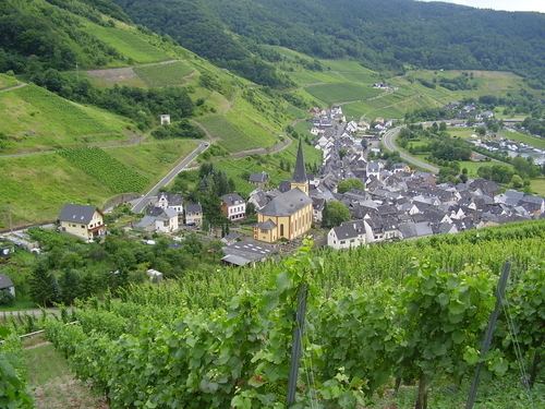
The municipality lies on both banks of the river Moselle. The bigger of the two centres, also called Senheim, lies on the right bank at the foot of the Hunsrück, while the considerably smaller centre of Senhals lies on the left bank, or the “Eifel side”. The two centres have been linked by bridge since 1967.
Constituent communities
Senheim’s Ortsteile are Senheim and Senhals.
History
The earliest record, from 1067, establishes the existence of holdings of the Cologne Church in Senhals. Senheim had its first documentary mention in 1140.
Three lords held sway in Senheim, namely the Elector of Trier, the Count of Sponheim and the Lords of Braunshorn-Metternich-Beilstein.
Senheim-Senhals was in the Middle Ages an important way station on the trade road that ran from the Netherlands through the Eifel by way of Senheim, through the Hunsrück and on to Frankfurt am Main and Augsburg. As far back as the Middle Ages, Senheimers earned their livelihood in winegrowing and agriculture (using a kind of shifting cultivation). It can be seen from the 1702 Electoral-Trier taxation statistics that vineyard holdings in the church’s and the nobility’s hands amounted to 300,000 vines. Winemakers held 200,000. The Sponheims held the other 100,000.
Beginning in 1778, the Electorate of Trier was the sole landholder. During the French Revolutionary Wars, the region was occupied by French troops in 1793 and 1794. In 1798, the region was made part of the Department of Rhin-et-Moselle, and thereby became part of France. In 1815 it was assigned to the Kingdom of Prussia at the Congress of Vienna.
The Senheim of the 17th and 18th centuries with its fortifications, towers, crenellations and gates, and its great number of stately noble and monastic estates, came to a sudden end on 13 August 1839: a great fire reduced the mediaeval village in a short time to ashes and rubble. Burnt down in this catastrophe were 106 houses, 22 winepress houses and 7 barns. The Catholic church, built in 1075 with its grand Baroque altar by Januarius Zick and the rectory came through the fire unscathed. When reconstruction was undertaken, an extensive plan was developed which left 30 local families without a place to live in the village. For them, a new, outlying centre was established up on the Hunsrück’s heights. It was named the “colony” of Hoch-Senheim (hoch means “high” in German), although soon after it was finished, it was given the name Moritzheim to honour its sponsor, the Landrat (district chairman) Moritz.
Since 1946, Senheim has been part of the then newly founded state of Rhineland-Palatinate. Under the Verwaltungsvereinfachungsgesetz (“Administration Simplification Law”) of 18 July 1970, with effect from 7 November 1970, the municipality was grouped into the Verbandsgemeinde of Cochem.
Municipal council
The council is made up of 12 council members, who were elected by majority vote at the municipal election held on 7 June 2009, and the honorary mayor as chairman.
Mayor
Senheim’s mayor is Lothar Stenz, and his deputies are Markus Görgen and Volker Ahnen.
Coat of arms
The German blazon reads: Das Wappen der Gemeinde Senheim zeigt in Schwarz drei (2 : 1) rotbewehrte silberne Löwen..
The municipality’s arms might in English heraldic language be described thus: Sable three lions rampant argent armed and langued gules.
Town partnerships
Senheim fosters partnerships with the following places:
Both these partnerships have been in place since 1935, and both take the form of a sponsorship, whose main aim is to “stabilize” Senheim’s wine festival and other local events through participation of people from these two sponsoring places.
Buildings
The following are listed buildings or sites in Rhineland-Palatinate’s Directory of Cultural Monuments: