
Country United States FIPS code 29-66674 Elevation 258 m Zip code 64865 Local time Wednesday 8:53 AM | Time zone Central (CST) (UTC-6) GNIS feature ID 0726201 Area 6.63 km² Population 2,406 (2013) Area code 417 | |
 | ||
Weather 15°C, Wind SE at 23 km/h, 95% Humidity | ||
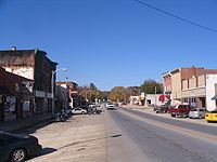
Seneca is a city in Newton County, Missouri, United States. The population was 2,336 at the 2010 census. It is part of the Joplin, Missouri Metropolitan Statistical Area.
Contents
- Map of Seneca MO 64865 USA
- History
- Geography
- 2010 census
- 2000 census
- Location and industry
- Notable natives
- References
Map of Seneca, MO 64865, USA
History
Seneca was platted in 1869. The city was named for the Seneca Indian tribe. A post office called Seneca has been in operation since 1869.
Several houses in the rural northern Seneca area were destroyed by a tornado on Saturday May 10, 2008 in the Mid-May 2008 tornado outbreak sequence in which an EF4 tornado hit the county killing 13 people. The Early Show broadcast their national weather report from the city on the following Monday morning. On the one year anniversary, Bill Lant, owner of Lant's Feed and Country Store, unveiled a memorial for the people who perished from the tornado. He had donated the plot of land and memorial and had the memorial built next to his store.
Geography
Seneca is located at 36°50′25″N 94°36′36″W (36.840318, -94.609918).
According to the United States Census Bureau, the city has a total area of 2.56 square miles (6.63 km2), all of it land.
2010 census
As of the census of 2010, there were 2,336 people, 877 households, and 612 families residing in the city. The population density was 912.5 inhabitants per square mile (352.3/km2). There were 962 housing units at an average density of 375.8 per square mile (145.1/km2). The racial makeup of the city was 85.3% White, 0.3% African American, 8.0% Native American, 0.4% Asian, 0.1% Pacific Islander, 0.4% from other races, and 5.5% from two or more races. Hispanic or Latino of any race were 2.2% of the population.
There were 877 households of which 40.5% had children under the age of 18 living with them, 48.2% were married couples living together, 16.0% had a female householder with no husband present, 5.6% had a male householder with no wife present, and 30.2% were non-families. 26.7% of all households were made up of individuals and 14% had someone living alone who was 65 years of age or older. The average household size was 2.60 and the average family size was 3.13.
The median age in the city was 35.3 years. 28.9% of residents were under the age of 18; 8.1% were between the ages of 18 and 24; 24% were from 25 to 44; 21.5% were from 45 to 64; and 17.3% were 65 years of age or older. The gender makeup of the city was 47.9% male and 52.1% female.
2000 census
As of the census of 2000, there were 2,135 people, 820 households, and 575 families residing in the city. The population density was 1,231.2 people per square mile (476.5/km²). There were 876 housing units at an average density of 505.2 per square mile (195.5/km²). The racial makeup of the city was 88.99% White, 0.09% African American, 6.56% Native American, 0.23% Asian, 0.09% Pacific Islander, 0.33% from other races, and 3.70% from two or more races. Hispanic or Latino of any race were 1.12% of the population.
There were 820 households out of which 35.1% had children under the age of 18 living with them, 54.6% were married couples living together, 13.0% had a female householder with no husband present, and 29.8% were non-families. 27.7% of all households were made up of individuals and 14.5% had someone living alone who was 65 years of age or older. The average household size was 2.49 and the average family size was 3.00.
In the city the population was spread out with 26.9% under the age of 18, 8.0% from 18 to 24, 25.3% from 25 to 44, 19.8% from 45 to 64, and 20.0% who were 65 years of age or older. The median age was 38 years. For every 100 females there were 81.7 males. For every 100 females age 18 and over, there were 75.4 males.
The median income for a household in the city was $29,441, and the median income for a family was $37,566. Males had a median income of $28,264 versus $19,662 for females. The per capita income for the city was $14,525. About 8.8% of families and 14.1% of the population were below the poverty line, including 15.4% of those under age 18 and 15.8% of those age 65 or over.
Location and industry
Seneca is located in Lost Creek Valley 5 miles upstream from the Grand Lake of the Cherokees and 5 miles downstream from the quaint Old Settler's town of Racine. The Frisco Railroad (now Burlington-Northern) runs through this valley. Prior to 1959, highway traffic to and from Oklahoma largely followed US 60 through Seneca rather than the more famous U.S. Route 66 with which it joins about 15 miles west of Seneca. At that time Seneca was a thriving roadside stop.
A landmark in Seneca is the giant can of Milnot (an evaporated milk product that substitutes vegetable oil for the butter-fat) located on the factory roof at the State Line. Before the Oklahoma toll-road to Joplin was opened in 1959, this landmark on US Route 60 meant "Welcome to Missouri". It has now been updated to the new label design, since J. M. Smucker took over ownership.
Seneca is home to American Tripoli, producer of "Seneca Standard" grades of tripoli, a naturally occurring microcrystalline silica product which is used as an abrasive and metal polishing compound. Processing is done in Seneca, but much of the raw material is now mined in Oklahoma.