
Time zone CAT (UTC+2) | Elevation 2,275 m | |
 | ||
Where to stay in lesotho semonkong lodge
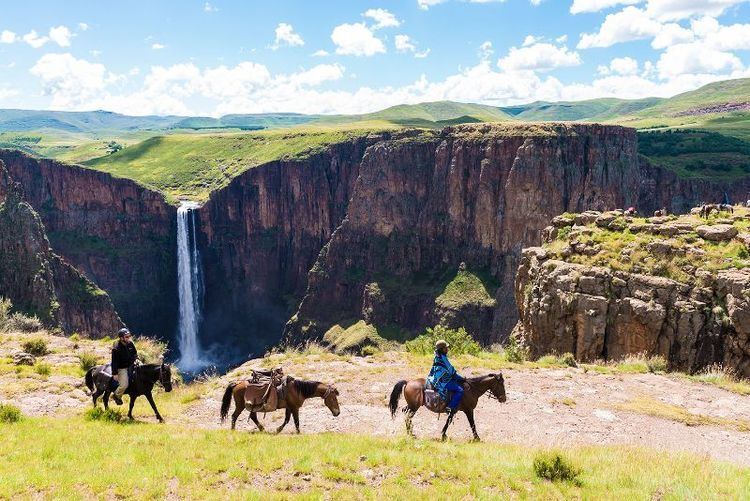
Semonkong is a community council located in the Maseru District of Lesotho. Semonkong, meaning "Place of Smoke", was established in the 1880s as a refuge for Basotho displaced by the Gun War. It is located close to several major natural features, including the Maletsunyane Falls and the 3096-metre peak of Thaba Putsoa. The population in 2006 was 7,781.
Contents
- Where to stay in lesotho semonkong lodge
- Map of Semonkong Lesotho
- Tourism is booming again in semonkong lesotho
- Villages
- References
Map of Semonkong, Lesotho
Tourism is booming again in semonkong lesotho
Villages
The community of Semonkong includes the villages of Boitumelo, Ha Farelane, Ha Khonyeli, Ha Lentiti, Ha Lepae, Ha Lesala, Ha Lesia, Ha Leteketa, Ha Mateketa, Ha Moahloli, Ha Moahloli (Qoang), Ha Moahloli (Thusong), Ha Moqibi, Ha Motšoane, Ha Phallang, Ha Ramabanta, Ha Rasefale, Ha Seqhoasho, Ha Sethuoa-Majoe, Ha Sikeme, Ha Tlalinyana (Likoeneng), Ha Tšitso, Letlapeng, Letšeng, Mabote, Mantorina, Meeling, Moriting, Mosoang, Motse-Mocha, Pontšeng, Sekhutlong, Thaba-Chitja, Tsekana, Tšenekeng and Tšoeu-tšoana.