Trisha Shetty (Editor)

Sematan

Updated on
Edit
Like
Comment
Share on FacebookTweet on TwitterShare on LinkedInShare on Reddit
Country
  
Malaysia

Elevation
  
1 m

Administrative division
  
Lundu

State
  
Sarawak

Local time
  
Monday 11:11 AM

Sematan wwwtravelbugholidaycomwpcontentuploads20120

Weather
  
31°C, Wind NE at 6 km/h, 76% Humidity

Sematan (also known as Simatan) is a settlement in the Lundu district of Sarawak, Malaysia. It lies approximately 67.5 kilometres (42 mi) west-north-west of the state capital Kuching.

Map of 94100 Sematan, Sarawak, Malaysia

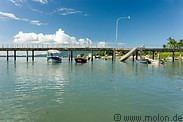
Sematan is a fishing village looking out over the South China Sea. It has reasonably clean beaches, a promenade along the waterfront and a concrete pier into the sea. At the north end there is a park celebrating early Malay fishermen in the Sematan area. Accommodation in Sematan can be had at the Sematan Hotel.

Neighbouring settlements include:

  • Kampung Tanah Hitam 0 kilometres (0.0 mi) north
  • Kampung Sebat 1.9 kilometres (1.2 mi) west
  • Kampung Tembaga 2.6 kilometres (1.6 mi) southwest
  • Kampung Perigi 4.1 kilometres (2.5 mi) southeast
  • Kampung Seru Laut 5.2 kilometres (3.2 mi) northwest
  • Kampung Paon 5.9 kilometres (3.7 mi) south
  • Kampung Siru 6.7 kilometres (4.2 mi) northwest
  • Kampung Serayan 7.4 kilometres (4.6 mi) south
  • Kampung Selarat 7.6 kilometres (4.7 mi) south
  • Pelaman Siru 8.3 kilometres (5.2 mi) northwest
  • References

    Sematan Wikipedia