
Primary outflows Grisefjorden Max. width 3 kilometres (1.9 mi) Surface elevation 32 m Shore length 31.48 km | Surface area 5.7 km (2.2 sq mi) Area 5.7 km² | |
 | ||
Max. length 5.6 kilometres (3.5 mi) Reference Norwegian Water Resources and Energy Directorate | ||
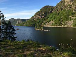
Selura is a lake in the municipality of Flekkefjord in Vest-Agder county, Norway. The 5.7-square-kilometre (2.2 sq mi) lake is located at an elevation of 32 metres (105 ft) above sea level and it is about 130 metres (430 ft) at its deepest. The lake lies immediately northeast of the town of Flekkefjord
Map of Selura, 4400 Flekkefjord, Norway
Selurafossen, the waterfall at the outflow of Lake Selura, historically provided a source of power for some industries, including a barrel factory and tannery in Flekkefjord.
References
Selura Wikipedia(Text) CC BY-SA