
Traversed by Track or trail Elevation 2,612 m | ||
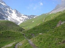 | ||
Cows with bells on the way to sefinenfurgge pass bernese oberland switzerland
The Sefinafurgga (Swiss German, Germanized: Sefinenfurgge) is a mountain pass of the Bernese Alps. The pass crosses the col between the peaks of Hundshore and Bütlasse, at an elevation of 2,612 m (8,570 ft).
Contents
- Cows with bells on the way to sefinenfurgge pass bernese oberland switzerland
- Map of Sefinenfurgge 3826 Reichenbach im Kandertal Switzerland
- References
Map of Sefinenfurgge, 3826 Reichenbach im Kandertal, Switzerland
The pass is traversed by a hiking track, which connects the village of Lauterbrunnen, at an elevation of 795 m (2,608 ft), and the Alpine hamlet of Griesalp, at an elevation of 1,408 m (4,619 ft) in the upper Kiental south of Reichenbach im Kandertal at the entrance of the Kiental. The track forms part of the Alpine Pass Route, a long-distance hiking trail across Switzerland between Sargans and Montreux.
References
Sefinenfurgge Pass Wikipedia(Text) CC BY-SA