
 | ||
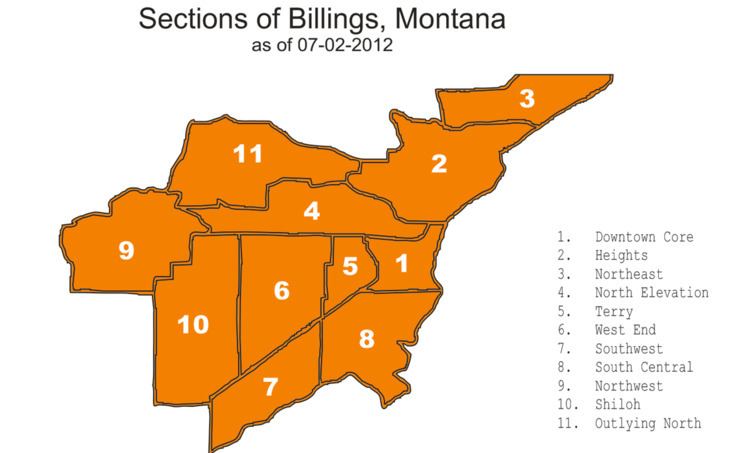
Downtown Core
This is the main financial, business, cultural and medical area of Billings and the surrounding areas and is home to several high-rise buildings including Montana's tallest high-rise, the First Interstate Center.
Contents
- Downtown Core
- Heights
- Northeast
- North Elevation
- Terry
- West End
- Southwest
- Northwest
- Shiloh
- Outlying North
- References
Neighborhoods in this section:
Heights
Located Northeast of the Downtown Core, was annexed into the city in the mid 1980s. This area is where the Lake Hills Golf Course.
Neighborhoods in this section:
Northeast
Northeast is bordered by Roundup Road, Mary Street, Dury Lane and the Yellowstone River. Located northeast of the Heights.
North Elevation
This area is where the Rimrocks rise up above the Yellowstone Valley.
Neighborhoods in this section:
Terry
This area is where Central and Terry parks are located. Also where Billings Central Catholic High School is located.
Neighborhoods in this section:
West End
Widely known as the West End or West Side, this is one of the fastest growing areas in Billings. The West End is the home of Rimrock Mall and Billings West High School, the home of the Bears. The local middle school is Will James, and Meadowlark Elementary is for K-6 graders.
Neighborhoods in this section:
Southwest
This is the area where one of the three area oil refineries and the Sugar Beet processing plant in the Billings Metro Area is located. It will soon be the location for a new retail/commercial development called Billings Town Square in which Cabelas will be the anchor tenant.
Neighborhoods in this section:
Northwest
This area typically encompasses the area north of Grand Avenue and west of Shiloh. This area tends to be the more affluent part of town.
Neighborhoods in this section:
Shiloh
It is located to the west of the West End - Descro area, and is centered around Shiloh Road, a north-south arterial which in 2008 underwent a major widening project that included the addition of 7 roundabouts. Near the southern part of this section of Billings, south of King Avenue West, a shopping district called Shiloh Crossing was built around the same time, consisting of a movie theater and various restaurants, shops and department stores including Kohl's.
Neighborhoods in this section:
Outlying North
This area is located north of the Airport and west of the Heights and is where the Billings Bypass is proposed to link the West End to the Heights.
Neighborhoods in this section: