
 | ||
Seasonal flows on warm Martian slopes (also called recurring slope lineae, recurrent slope lineae and RSL) are thought to be salty water flows occurring during the warmest months on Mars.
Contents
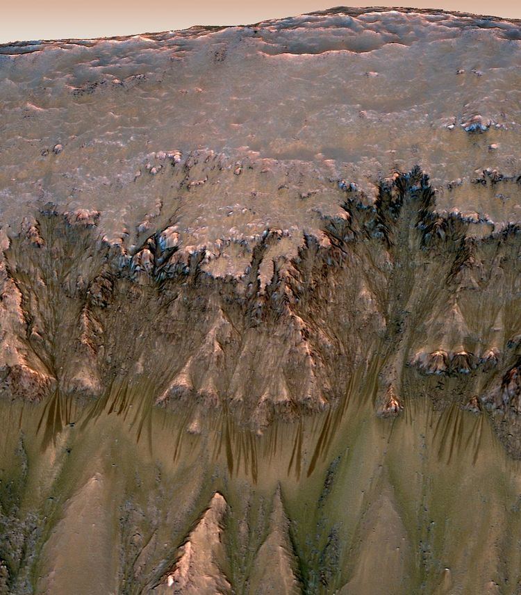
The flows are narrow (0.5 to 5 meters) and exhibit relatively dark markings on steep (25° to 40°) slopes, appear and incrementally grow during warm seasons and fade in cold seasons. Liquid brines near the surface almost certainly explain this activity, but the exact source of the water and the mechanism behind its motion are not understood. On October 5, 2015, possible RSLs were reported on Mount Sharp near the Curiosity rover.
Overview
Research indicates that in the past there was liquid water flowing on the surface of Mars, creating large areas similar to Earth's oceans. However, the question remains as to where the water has gone.
The Mars Reconnaissance Orbiter (MRO) is a multipurpose spacecraft launched in 2005 designed to conduct reconnaissance and exploration of Mars from orbit. The spacecraft is managed by the Jet Propulsion Laboratory (JPL). The HiRISE instrument is at the forefront of the ongoing RSL studies as it helps chart the features with images of closely monitored sites typically taken every few weeks.
Features
Distinctive properties of recurring slope lineae (RSL) include slow incremental growth, formation on warm slopes in warm seasons, and annual fading and recurrence, showing a strong correlation with solar heating. RSL extend down slope from bedrock outcrops often following small gullies about 0.5 to 5 meters (1 ft 8 in to 16 ft 5 in) wide, with lengths up to hundreds of meters, and some of the locations display more than 1,000 individual flows. RSL advance rates are highest at the beginning of each season, followed by much slower lengthening. RSL appear and lengthen in the late southern spring and summer from 48°S to 32°S latitudes that favor equator-facing slopes, which are times and places with peak surface temperatures from −23 °C to 27 °C. Active RSL also occur in equatorial regions (0–15°S), most commonly in the Valles Marineris troughs.
Researchers surveyed flow-marked slopes with the Mars Reconnaissance Orbiter's CRISM and although there is no spectrographic evidence for actual water, the instrument has now directly imaged perchlorate salts thought to be dissolved in water brines in the subsurface. This may indicate the water quickly evaporates upon reaching the surface, leaving only the salts. The cause of the surface darkening and lightening is poorly understood: a flow initiated by salty water (brine) could rearrange grains or change surface roughness in a way that darkens the appearance, but the way the features brighten again when temperatures drop is harder to explain.
Hypotheses
A number of different hypotheses for RSL formation have been proposed. The seasonality, latitude distribution, and brightness changes strongly indicate a volatile material —such as water or liquid CO
2 — is involved. One hypothesis is that RSL could form by rapid heating of nocturnal frost. Another one proposes flows of carbon dioxide, but the settings in which the flows occur are too warm for carbon-dioxide frost (CO
2), and at some sites is too cold for pure water. Other hypotheses include dry granular flows, but no entirely dry process can explain seasonal flows that progressively grow over weeks and months. Seasonal melting of shallow ice would explain the RSL observations, but it would be difficult to replenish such ice annually. However, recent direct observations of seasonal deposition of soluble salts strongly suggest that RSL are created by a water brine.
Brines
The leading hypothesis involves the flow of brines —very salty water. Salt deposits over much of Mars indicate that brine was abundant in Mars's past. Salinity lowers the freezing point of water to sustain a liquid flow. Less saline water would freeze at the observed temperatures. Thermal infrared data from the Thermal Emission Imaging System (THEMIS) on board the 2001 Mars Odyssey orbiter, have allowed the temperature conditions under which RSL form to be constrained. While a small number of RSL are visible at temperatures above the freezing point of water, most are not, and many appear at temperatures as low as −43 °C (230 K). Some scientists think that under these cold conditions, a brine of iron(III) sulphate (Fe2(SO4)3) or calcium chloride (CaCl
2) is the most likely mode of RSL formation. Another team of scientists, using the CRISM instrument onboard MRO, reported that the evidence for hydrated salts is most consistent with the spectral absorption features of magnesium perchlorate (Mg(ClO4)2), magnesium chloride (MgCl2(H2O)x) and sodium perchlorate (NaClO
4).
These observations are the closest scientists have come to finding evidence of liquid water on the planet's surface today. Frozen water, however, has been detected near the surface in many middle to high-latitude regions. Purported droplets of brine also appeared on struts of the Phoenix Mars Lander in 2008.
Source of water
Liquid brine flows near the surface might explain this activity, but the exact source of the water and the mechanism behind its motion are not understood. A hypothesis proposes that the needed water could originate in the seasonal oscillations of near-surface adsorbed water provided by the atmosphere; perchlorates and other salts known to be present on the surface, are able to attract and hold water molecules from the surrounding environment (hygroscopic salts), but the dryness of the Martian air is a challenge. Water vapor must be efficiently trapped over very small areas, and seasonal variation in the atmospheric column abundance of water vapor does not match the RSL activity over active locations.
Deeper groundwater may exist and could reach the surface at springs or seeps, but this cannot explain the wide distribution of RSL, extending from the tops of ridges and peaks. Also, there are apparent RSL on equatorial dunes composed of permeable sand, unlikely to be a groundwater source.
Habitability
These features form on sun-facing slopes at times of the year when the local temperatures reach above the melting point for ice. The streaks grow in spring, widen in late summer and then fade away in autumn. This is hard to model in any other way except as involving liquid water in some form, though the streaks themselves are thought to be a secondary effect and not a direct indication of dampness of the regolith. Although these features are now confirmed to involve liquid water in some form, the water could be either too cold or too salty for life. At present they are treated as potentially habitable, as "Uncertain Regions, to be treated as Special Regions".
The "Special Regions" assessment says of them:
Here a "Special Region" is defined as a region on the Mars surface where Earth life could potentially survive.
They were first reported in the paper by McEwan in Science, August 5, 2011. They were already suspected as involving flowing brines back then, as all the other models available involved liquid water in some form.
They were finally proven to involve liquid water, pretty much conclusively after detection of hydrated salts that change their hydration state rapidly through the season. This was the subject of a major NASA news announcement and press conference and also reported in a paper published on 28 September 2015. The brines were not detected directly, because the resolution of the spectrometer isn't high enough for this, and also the brines probably flow in the morning. The spacecraft which observed, them, the Mars Reconnaissance Orbiter, is in a slowly precessing sun-synchronous orbit inclined at 93 degrees (orbital period 1 hr 52 minutes). Each time it crosses the Mars equator on the sunny side, South to North, the time is 3:00 pm, in the local solar time on the surface, all year round. This is the worst time of day to spot brines from orbit.
The evidence also suggests fairly substantial amounts of water, at least for microbes. At the end of the press conference, the researchers gave a rough estimate of a total annual flow of at least 100,000 tons for the entire Valles Marineres region. In this calculation they assumed only 5% water in the solution and a film with a thickness of 10 mm which is about what you need for the material to flow at all. They are amongst the most favoured candidate sites for present day life on Mars. Whether they are habitable or not will depend on the temperature of the water and its salinity.