A seagull intersection or continuous green T-intersection (also known as a turbo-T (in Florida) or High-T intersection (in Nevada and Utah)) is a type of three-way road intersection, usually used on high traffic volume roads and dual carriageways. This form of intersection is popular in Australia and New Zealand, and sometimes used in the United States and other countries.
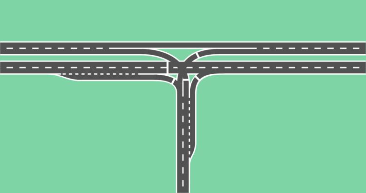
Seagull intersections get their name from the pattern that the two right-turn lanes make when looking down from the air.
In a seagull intersection, one or more lanes of traffic on the arterial road, on the carriageway opposite the intersecting side road, are free flowing, that is, one direction of traffic on the arterial is allowed to travel straight through without stopping. The free-flowing lane(s) are called "continuous green through lane(s)" (CGTL). For the free-flowing through lanes, access into and out of the side road is provided via turn lanes separated from the through lanes in a configuration similar to exit and entrance ramps at an interchange; however, the turn lanes are at the same grade as both carriageways of the arterial and are located on the same side as the oncoming traffic.
Those wishing to turn right into the side road at the intersection, bear right into the turn lane, which forms one "wing" of the seagull. Here, they meet the opposite carriageway and the side road. Traffic wishing to turn right out of the side road, cross the intersecting carriageway, drive up the other "wing" of the seagull, and merge onto the other carriageway.
For the arterial carriageway adjacent to the side road, access into and out of the side road is ordinarily handled like a conventional T intersection. However, some seagull intersections may have a second, smaller "seagull" formed by two left turning lanes into and out of the side road.
Different methods are used to control traffic where two right-turning movements and the through movement meet. Most intersections use traffic lights, while others use give way (yield) and stop signs, and sometimes roundabouts.
This design type has been proven to provide sustainable benefits when compared the traditional T-intersection design. By reducing delay through the intersection, automobiles use less fuel on average passing through the intersection, and thus emissions are reduced across the intersection. The savings per vehicle may not seem very significant, but when scaled to account for all automobiles passing through the intersection, the total emission savings are significant. Additionally, there are economic and social benefits to reducing delay time and allowing drivers to pass through the intersection quicker. In the Netherlands, this type of intersection occurs by default when a T-junction has a bicycle path on the continuing road, and is not intersected by a roadway for motorized vehicles. The bicycle path may ignore red lights; it is only turning cyclists that must wait for the red light.
An experiment was done in Illinois, United States to allow going straight on red (following rules analogous to those used for turns on red) when approaching a T junction on the main road, with the intersecting road on the left. It was a failure. However, at some T junctions where the main road includes at least two lanes on the side away from the intersecting road, the farthest (rightmost, in areas where traffic drives to the right) lane is given the right of way to proceed straight through the intersection at all times, denoted by a "green arrow" signal if a traffic light is installed at the intersection. In such cases, often that lane is also specially delimited with pavement markings or other lane separation devices, to keep left-turning traffic on the intersecting road from colliding with traffic proceeding through the intersection on the main road. The seagull intersection was developed as a safer variation of this.
Cotter Road at Streeton Drive – Weston Creek (near Canberra) 35.326214°S 149.053649°E / -35.326214; 149.053649Ginninderra Drive at William Slim Drive - Belconnen (near Canberra) 35.22593°S 149.07425°E / -35.22593; 149.07425Ginninderra Drive at Tillyard Drive - Belconnen (near Canberra) 35.207320°S 149.034212°E / -35.207320; 149.034212Highway 1 (Princes Highway) at Island Point Road – Tomerong, New South Wales 35.071259°S 150.570555°E / -35.071259; 150.570555Highway 1 (Princes Highway) at Kells Road – Tomerong, New South Wales 35.065268°S 150.573018°E / -35.065268; 150.573018In the Municipality of Delta, British Columbia:
at 72 Street and Hwy 91 49.133989°N 122.928792°W / 49.133989; -122.928792In City of Saskatoon:
at College Drive to Central Avenue 52.128542°N 106.59906°W / 52.128542; -106.59906at Circle Drive to Airport Drive 52.15487°N 106.68165°W / 52.15487; -106.68165at Circle Drive to Laurier Drive 52.134344°N 106.717849°W / 52.134344; -106.717849at Circle Drive to Clancy Drive 52.121965°N 106.718134°W / 52.121965; -106.718134at 22nd Street to Hart Road 52.129532°N 106.739181°W / 52.129532; -106.739181at Hauptstraße (L23) / Bundesstraße 51 in Olzheim 50.2679397°N 6.4557822°E / 50.2679397; 6.4557822at Hauptstraße (L204) / Bundesstraße 51 in Dahlem (Nordeifel) 50.4057034°N 6.5679529°E / 50.4057034; 6.5679529at Greven Interchange of Bundesautobahn 1 to Bundesstraße 481 52.083297°N 7.645088°E / 52.083297; 7.645088 and 52.084701°N 7.642931°E / 52.084701; 7.642931at Würselen Interchange of Bundesautobahn 544 to Verlautenheidener Straße (L23) 50.801106°N 6.149961°E / 50.801106; 6.149961New Zealand
Upper Harbour Highway (State Highway 18) at Paul Matthews Drive – North Shore, Auckland 36.75262°S 174.71571°E / -36.75262; 174.71571Wairau Road at Forrest Hill Road – Takapuna, Auckland 36.78012°S 174.74988°E / -36.78012; 174.74988Hutt Road at Onslow Road - KaiwharawharaWaikato Expressway (SH 1) at Island Block Road, Springhill Road, and Dragway Road – MeremereState Highway 1 at Whitford Brown Drive – Porirua 41.12093°S 174.85414°E / -41.12093; 174.85414River Road (SH 2) at Gibbons Street – Upper Hutt 41.11619°S 175.06535°E / -41.11619; 175.06535Western Hutt Road (SH 2)/River Road (SH 2) at Fergusson Drive – Silverstream, Upper Hutt 41.14496°S 174.99626°E / -41.14496; 174.99626Poland
aleja Młodzieży Polskiej (National Road 31) at Kościuszki (National Road 29) - Słubice 52.348968°N 14.562536°E / 52.348968; 14.56253624th Street at Lincoln Drive - Phoenix, Arizona 33.531466°N 112.025863°W / 33.531466; -112.025863In Tucson, Arizona:W. Anklam Road at Pima Community College main entrance 32.225041°N 111.016369°W / 32.225041; -111.016369S. Wilmot Road at Park Place mall entrance 32.218080°N 110.858012°W / 32.218080; -110.858012US 285 at US 24 – Buena Vista, Colorado 38.809688°N 106.115835°W / 38.809688; -106.115835US 160 at US 550 – Durango, Colorado 37.221657°N 107.846454°W / 37.221657; -107.846454US 50 at SH 141 – Grand Junction, Colorado 39.014474°N 108.474751°W / 39.014474; -108.474751NASA Parkway at Space Commerce Way - Brevard County, Florida east of Titusville, Florida and just west of the Kennedy Space Center Visitor Complex 28.5261243°N 80.6930173°W / 28.5261243; -80.6930173Radio City Drive (IL 29) at Edgewater Drive (IL 98) - Pekin and North Pekin, Illinois 40.604146°N 89.63688°W / 40.604146; -89.63688N. Sheridan Road at shopping center entrance - Peoria, Illinois 40.741885°N 89.603023°W / 40.741885; -89.603023MD 210 at MD 228 - Accokeek, Maryland, opened in 2000, is a hybrid, also having characteristics of a continuous-flow intersection. 38.664126°N 77.016928°W / 38.664126; -77.016928In Boulder City, Nevada:US 93 (Great Basin Highway) at Lake Mountain Drive 35.988124°N 114.834123°W / 35.988124; -114.834123US 93 (Great Basin Highway) at Lakeshore Road 36.009039°N 114.799866°W / 36.009039; -114.799866Cheyenne Avenue in Las Vegas, Nevada has four seagull intersections between Clark County Route 215 and Rampart Boulevard.Oregon Route 213 at its north terminus with Airport Way - Portland, Oregon 45.581000°N 122.572542°W / 45.581000; -122.572542US 83/US 84 east/US 277 (Winters Freeway) at Bus. I-20-R/US 84 west (South 1st Street) – Abilene, Texas. Folded diamond ramps from Winters Freeway form continuous green T intersections with South 1st Street. 32.452182°N 99.784935°W / 32.452182; -99.784935East Riverside Drive at South Lakeshore Boulevard - Austin, Texas 30.244767°N 97.730440°W / 30.244767; -97.730440Allen Parkway at Taft Street – Houston, Texas 29.761243°N 95.385820°W / 29.761243; -95.385820Bicentennial Boulevard at Lark Avenue – McAllen, Texas 26.260774°N 98.229738°W / 26.260774; -98.229738SR-201 at SR-111 – Magna, Utah 40.717583°N 112.091726°W / 40.717583; -112.091726