
Country United States County Cayuga FIPS code 36-65816 Elevation 370 m Population 1,713 (2010) Area code 315 | State New York Time zone Eastern (EST) (UTC-5) GNIS feature ID 0979476 Zip code 13147 Local time Friday 4:59 PM | |
 | ||
Weather 7°C, Wind S at 16 km/h, 75% Humidity Area 101.8 km² (94.79 km² Land / 6.993 km² Water) | ||
Scipio is a town in Cayuga County, New York, United States. The population was 1,713 at the 2010 census. The town name was provided by a clerk with an interest in the classics. Scipio is centrally located in the southern half of the county, south of Auburn.
Contents
- Map of Scipio NY USA
- History
- Geography
- Demographics
- Tourism
- Notable people
- Hocus Pocus
- Communities and locations in Scipio
- References
Map of Scipio, NY, USA
History
Scipio was part of the Central New York Military Tract, which was land reserved for veterans of the Revolutionary War. The first settler arrived around 1790, and the town was formed in 1798 when Cayuga County was formed. The town was named after the Roman general Scipio Africanus. In 1823, part of Scipio was used to form the towns of Springport and Venice.
Geography
According to the United States Census Bureau, the town has a total area of 39.3 square miles (101.8 km2), of which 36.6 square miles (94.7 km2) is land and 2.7 square miles (7.1 km2), or 7.00%, is water.
The east town line is marked by Owasco Lake, one of the Finger Lakes.
New York State Route 34, New York State Route 34B, and New York State Route 38 are north-south highways in Scipio.
Demographics
As of the census of 2000, there were 1,537 people, 571 households, and 424 families residing in the town. The population density was 41.9 people per square mile (16.2/km²). There were 702 housing units at an average density of 19.1 per square mile (7.4/km²). The racial makeup of the town was 97.59% White, 0.20% African American, 0.85% Native American, 0.59% Asian, 0.20% from other races, and 0.59% from two or more races. Hispanic or Latino of any race were 1.30% of the population.
There were 571 households out of which 36.6% had children under the age of 18 living with them, 60.6% were married couples living together, 7.7% had a female householder with no husband present, and 25.7% were non-families. 20.0% of all households were made up of individuals and 8.8% had someone living alone who was 65 years of age or older. The average household size was 2.69 and the average family size was 3.11.
In the town, the population was spread out with 29.0% under the age of 18, 6.8% from 18 to 24, 28.2% from 25 to 44, 24.7% from 45 to 64, and 11.5% who were 65 years of age or older. The median age was 37 years. For every 100 females there were 99.9 males. For every 100 females age 18 and over, there were 93.6 males.
The median income for a household in the town was $44,491, and the median income for a family was $50,395. Males had a median income of $34,671 versus $22,625 for females. The per capita income for the town was $17,705. About 2.8% of families and 6.7% of the population were below the poverty line, including 6.7% of those under age 18 and 6.7% of those age 65 or over.
Tourism
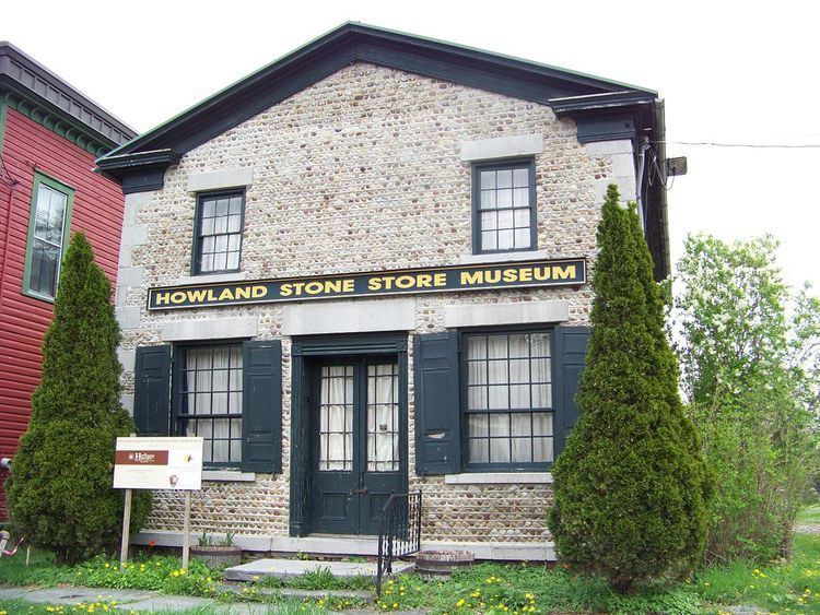
The Howland Cobblestone Store, also known as the Howland Stone Store Museum, is located in Scipio. The 19th-century store is significant for its cobblestone architecture and was listed on the National Register of Historic Places in 1994.
Notable people
Hocus Pocus
The town is the setting of the Kurt Vonnegut novel Hocus Pocus. Many details about the town are fictionalized for the novel.