
 | ||
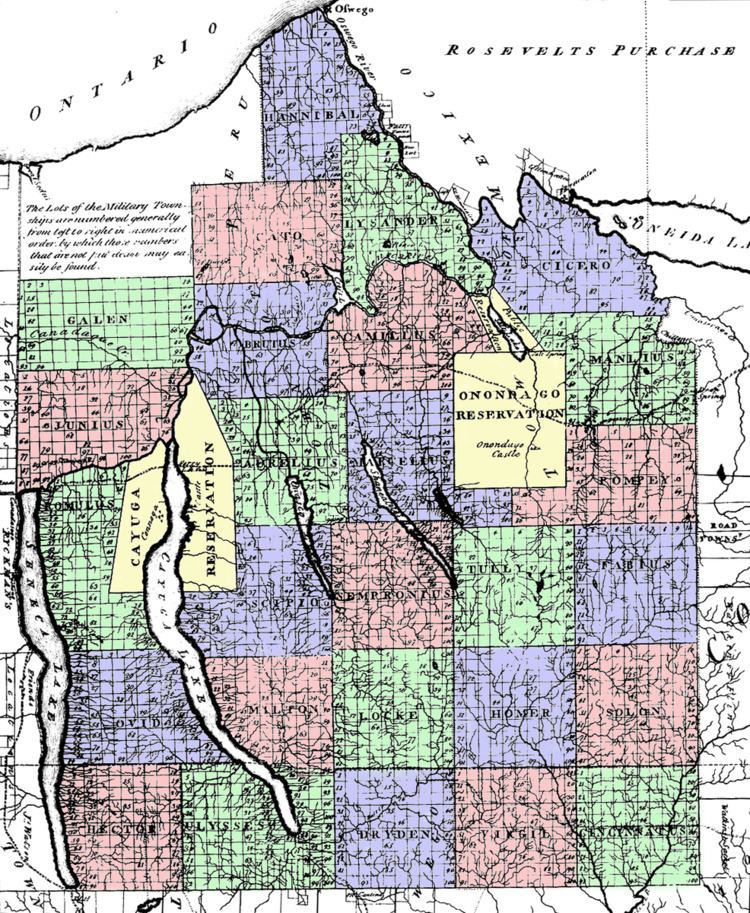
The Military Tract of Central New York, also called the New Military Tract, consisted of nearly two million acres (8,100 km2) of bounty land set aside to compensate New York's soldiers after their participation in the Revolutionary War.
The United States Congress had already guaranteed each soldier at least 100 acres (0.4 km2) at the end of the war (depending on rank), but by 1781, New York had enlisted only about half of the quota set by the U.S. congress and needed a stronger incentive. The state legislature authorized an additional 500 acres (2 km2) per soldier, using land from 25 Military Tract Townships to be established in central New York State. Each of the townships was to comprise 100 lots of 600 acres (2.4 km2) each. Three more such townships were later added to accommodate additional claims at the end of the war.
The townships were at first numbered (1 through 28), but were later given (mostly) classical Greek and Roman names, along with a few honoring English authors:
The tract covered the present counties of Cayuga, Cortland, Onondaga, and Seneca, and parts of Oswego, Tompkins, Schuyler and Wayne. Most of these township names are reflected in current town names in these counties, but the area of the military townships do not correspond exactly with any of the modern towns, which only cover a fraction of the original townships.
The names themselves have been attributed to Robert Harpur, a clerk in the office of New York's Surveyor General, Simeon De Witt. Harpur apparently had an interest in classical literature.
Townships were as far as geographically feasible made up of a 10x10 square of mile-square (640-acre [2.6 km2]) lots; 40 acres (16 ha) were used for boundary roads, leaving 600 acres (2.4 km2) to be deeded in each lot. Ninety-four lots in each Township were to be deeded, with the other six reserved for public purposes such as churches and schools.
The portion of the Military Tract north of Seneca Lake (i.e. townships of Galen and Junius) was divided by the New Preemption Line from land to its west assigned by the Treaty of Hartford of 1786 to Massachusetts. The tract immediately to the west became the Phelps and Gorham Purchase. The west limit of most of the tract was Seneca Lake.
Two Indian reservations were included in the Tract, for the Onondaga and Cayuga. All of the Cayuga and most of the Onondaga (including the City of Syracuse) were taken a few years later by New York State by treaties whose legality has been repeatedly challenged, since following the Trade and Intercourse Act of 1790 only the United States could conclude treaties with Indians.