
Elevation 479 m (1,572 ft) Area 26.9 km² Local time Friday 5:03 PM Dialling code 05686 | District Schwalm-Eder-Kreis Time zone CET/CEST (UTC+1/+2) Population 1,080 (30 Jun 2009) Postal code 34639 Administrative region Kassel | |
 | ||
Weather 8°C, Wind NE at 19 km/h, 59% Humidity | ||
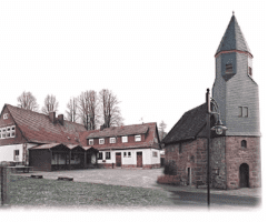
Schwarzenborn is the smallest town in Hesse, Germany.
Contents
- Map of Schwarzenborn Germany
- Location
- Constituent communities
- Coat of arms
- Town partnerships
- Economy and infrastructure
- Transport
- References
Map of Schwarzenborn, Germany
Location
Schwarzenborn lies in the Schwalm-Eder district some 13.5 km from Homberg in the Knüll. Through the constituent community of Grebenhagen flows the river Efze.
Constituent communities
The town consists of the two centres of Grebenhagen and Schwarzenborn.
Coat of arms
Schwarzenborn's civic coat of arms might be heraldically described thus: Argent a goat-headed spreadeagle sable langued gules, surmounted by an inescutcheon sable a mullet of six Or.
Schwarzenborn's arms bear a likeness to both Neukirchen's and Schwalmstadt's. All three have the goat-headed spreadeagle and a star on the inescutcheon (small shield within the bigger one), but colouring varies among the three.
Town partnerships
Economy and infrastructure
The town is well known for being a Bundeswehr base with a large training area, furnishing some 300 jobs to local civilians, making the Bundeswehr the town's biggest employer. The garrison is home of the Jägerregiment 1 (1st Ranger Regiment), which is the infantry element of the German Army's Luftbewegliche Brigade 1 (1st Air Mobile Brigade) at Fritzlar Army Base.
Transport
The Hersfeld-West Autobahn interchange on the A 7 (Kassel – Würzburg) is about 15 km away.
Schwarzenborn is joined to the railway network through the stations at Schwalmstadt-Treysa and Bad Hersfeld.