
Nearest city Fort Hunter, New York NRHP Reference # 66000530 Phone +1 518-829-7516 | Built 1841–1845 Designated NHL October 9, 1960 Added to NRHP 15 October 1966 | |
 | ||
Address 129 Schoharie St, Fort Hunter, NY 12069, USA Hours Open today · 10AM–5PMFriday10AM–5PMSaturday10AM–5PMSunday1–5PMMondayClosedTuesdayClosedWednesday10AM–5PMThursday10AM–5PMSuggest an edit Similar Clinton House, Steuben Memorial State Hist, Bristol Beach State Park, Sayville National Wildlife R, Hudson River Islands St Profiles | ||
Megan hicks schoharie crossing state historic site fort hunter ny
Schoharie Crossing State Historic Site, also known as Erie Canal National Historic Landmark, is a historic district that includes the ruins of the Erie Canal aqueduct over Schoharie Creek, and a 3.5-mile (5.6 km) long part of the Erie Canal, in the towns of Glen and Florida within Montgomery County, New York. It was the first part of the old canal to be designated a National Historic Landmark, prior to the designation of the entire New York State Barge Canal as a NHL in 2017.
Contents
- Megan hicks schoharie crossing state historic site fort hunter ny
- Tiononderoge and Fort Hunter
- The original Erie Canal
- The enlarged Erie Canal
- The NYS Barge Canal
- Schoharie Crossing State Historic Site
- References
Schoharie Crossing State Historic Site is the only location where all three phases of New York's Canals can be seen at once. In addition to the Schoharie Aqueduct, the only two remaining locks of the original canal can be found at Schoharie Crossing, as well as three enlarged canal locks and one barge canal lock.
Tiononderoge and Fort Hunter
Located at the south east corner of the confluence of the Mohawk River and Schoharie Creek was the Native American fortified village of Tiononderoge. The name is Mohawk meaning "the meeting of the waters". The settlement was occupied from around 1710 to the beginning of the American Revolutionary War in 1776. It has been estimated that approximately 360 people lived in the village in 1713, declining to 204 by 1750. Europeans called the village the Lower Castle from its position as the major eastern settlement (furthest downstream) of the Mohawk.
In 1710, Peter Schuyler, mayor of Albany, invited three Mohawk chiefs and one Mahican chief (of the Algonquian-speaking peoples) to travel to England and visit Queen Anne to solidify their trading alliance. The Mohawk chiefs asked for help in defense against the French, including Anglican missionaries to offset French Catholic influence among their people. Numerous Catholic Mohawk had moved up to the St. Lawrence River valley, where they settled south of Montreal at a village they named Kahnawake, after their former Caughnawaga in the Mohawk Valley.
The Mohawk offered help in settling Palatine German refugees in New York, who had arrived that year and were working in English camps along the Hudson River. Hendrick Tejonihokarawa offered Mohawk land near the Schoharie. Later it was offered to the Germans through Governor Hunter, and some settled in the Schoharie Valley.
As a result of the Mohawk request for aid, Queen Anne authorized Schuyler to build Fort Hunter, named after Colonial Governor Robert Hunter; the complex was completed in 1712, located near where Schoharie Creek entered the Mohawk River. The fort was 150-foot square with a blockhouse at each corner. The main gate faced north. A wooden chapel was built at the center. The chapel was named after Queen Anne, who sent communion silver and other items to furnish it.
In 1741, Queen Anne's Chapel was rebuilt using limestone blocks that were quarried locally. By 1775, colonists estimated 600 "praying Indians" (Christians) lived at Fort Hunter.
Shortly thereafter, fighting broke out in the Mohawk Valley and across the colonies as part of the American Revolution. The Mohawks sided with England, as they had for the previous century in conflicts with the French. Fighting alongside the British at the Battle of Oriskany and the Battle of Freeman's Farm, the Mohawk soon became disgusted with the British management of the conflicts and left to join their cousins, the Turtle clan, in the Saint Lawrence Valley.
In 1780, Mohawk warriors joined Sir John Johnson and Joseph Brant in fighting against the rebellious colonists in the Mohawk Valley. They participated in raids known as the "Burning of the Valleys." During one of the raids, a group of men retrieved Queen Anne's gifts, which had been buried at Fort Hunter. Today they are displayed at Brantford and Tyendinaga, Ontario, Canada.
After the American Revolutionary War, Queen Anne's Chapel was used for a time as a tavern and stable, to house the many migrants at Fort Hunter, which had developed into a village. They were moving west along the valley into areas of New York state newly opened for European-American settlement since the Iroquois, as allies of the British were forced to cede their lands after the British defeat. The chapel was torn down during the construction of the Erie Canal, completed in 1824.
The original Erie Canal
The Erie Canal was begun on July 4, 1817 in Rome, New York. Six years later the section of the canal through Fort Hunter was completed.
The canal originally crossed the creek in a slack water pool that was created by a dam, which can be seen when the water is low, further down the creek. Boats would then be towed across while mules and horses were ferried. A towpath bridge was later built to help mules cross but the boats still had to make the dangerous crossing.
Schoharie Crossing State Historic Site is one of the only sites where the Original Erie Canal remains. It runs from the Schoharie Creek to the Enlarged Erie Canal Lock 29. Along the way are some significant features.
Both Lock 20 and the guard lock were filled with gravel in 1980 to stabilize them.
The enlarged Erie Canal
Soon after the original Erie Canal was completed, traffic outgrew it. By the 1830s, it was decided that the entire length would have to be enlarged to keep up with growing trade.
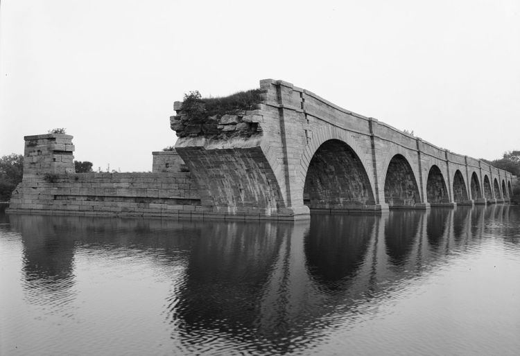
In Fort Hunter, the path of the canal was moved so that an aqueduct could be constructed across the Schoharie Creek. Construction began on the Schoharie Aqueduct in 1838 by Otis Eddy and was completed in 1841. Fourteen arches spanning 624 feet carried the Enlarged Erie Canal and towpath across the Schoharie Creek from 1845 until 1916.
In the 1940s, the Army Corps of Engineers demolished the easternmost six arches of the aqueduct to alleviate ice jams. A seventh arch collapsed during a 1977 flood, and an eighth collapsed on August 16, 1998. The latest collapse occurred during the flooding that followed Hurricane Irene in August 2011. Five arches remain standing today.
The aqueduct was named a National Historic Landmark in 1960.
The Schoharie Crossing State Historic Site includes many other remnants of the Enlarged Erie Canal.
The NYS Barge Canal
Traffic again outgrew the canal and it was decided at the beginning of the 20th century to abandon the enlarged Erie Canal and construct a new "Barge" Canal. From Cohoes to Herkimer, the Mohawk River was canalized and many locks were added. Lock 12 was constructed at Fort Hunter.
The canal opened in 1917 and remains in use today.
Schoharie Crossing State Historic Site
The Fort Hunter Canal Society was formed in the 1950s to preserve the ruins of the Erie Canal in Fort Hunter.
In 1966, the state-owned land at Fort Hunter was transferred to the New York State Office of Parks, Recreation and Historic Preservation and Schoharie Crossing State Historic Site was formed.
Throughout the years, many changes, additions, and improvements have been made.
The Visitor Center is located at 129 Schoharie Street in Fort Hunter, New York. The building was built as a boarding house in the 1890s and was used as such until it opened as the Visitor Center in the 1980s. When the parking lot was put in, remains of a stone wall were uncovered. The remains are believed to be associated with the original Fort Hunter and Queen Anne's Chapel. "Little Short of Madness" is the name of the permanent exhibit at the site. It brings visitors through the progression of the canal system in New York. Restrooms and a gift shop are located here.
Yankee Hill Picnic area is located on Queen Anne Street by Lock 28 and Putman's Canal Store.
A boat launch and picnic area are located at the end of Dufel Road on the west side of the Schoharie Creek.