
Location South China Sea Municipality Cijin, Kaohsiung | Prefecture-level city Sansha, Hainan Municipality Masinloc, Zambales | |
 | ||
Archipelago Land area: none - many rocks at low tide
Water area: ~150 km (58 sq mi) Highest point South Rock
1.8 meters (5.9 ft) | ||
Scarborough Shoal, also known as Huangyan Dao (simplified Chinese: 黄岩岛; traditional Chinese: 黃岩島; pinyin: Huángyán Dǎo), Democracy Reef (Chinese: 民主礁; pinyin: Mínzhǔ Jiāo), Bajo de Masinloc, or Panatag Shoal (Filipino: Kulumpol ng Panatag), is a shoal located between the Macclesfield Bank and Luzon island in South China Sea.
Contents
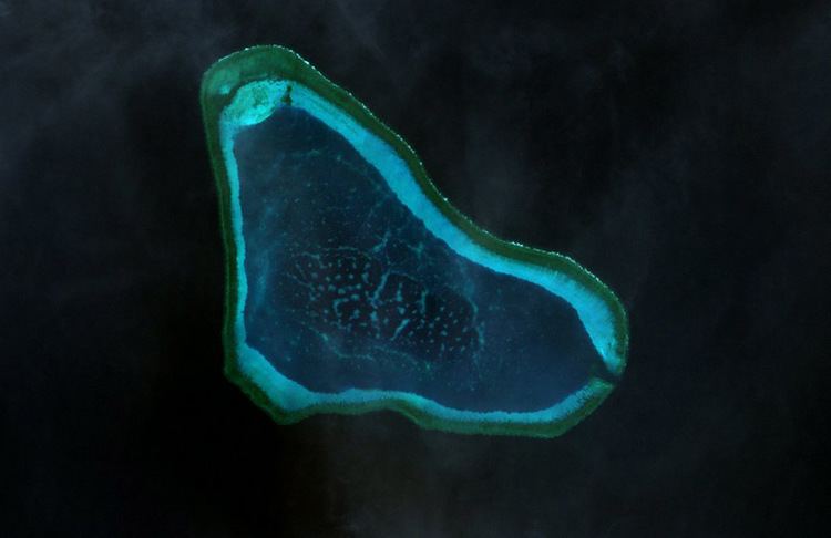
- Map of Scarborough Shoal
- Geography
- History
- Activities and Reclamation in the surrounding area
- Claims by China and Taiwan
- Claim by the Philippines
- PCA tribunals ruling
- References
Map of Scarborough Shoal
It is a disputed territory claimed by the People's Republic of China, the Republic of China (Taiwan), and the Philippines. The shoal's status is often discussed in conjunction with other territorial disputes in the South China Sea such as those involving the Spratly Islands. Since the 2012 Scarborough Shoal standoff, access to the shoal had been restricted by the People's Republic of China. However, in 2016, following meetings between the Philippine president Duterte and his Chinese counterparts, China allowed Filipino fishermen to once again access the shoals for fishing.
The shoal was named by Captain Philip D'Auvergne, whose East India Company East Indiaman Scarborough grounded on one of the rocks on 12 September 1784, before sailing on to China.
Geography
Scarborough Shoal forms a triangle-shaped chain of reefs and rocks with a perimeter of 46 km (29 mi). It covers an area, including an inner lagoon, of 150 km2 (58 sq mi). The shoal's highest point, South Rock, measures 1.8 m (5.9 ft) above water during high tide. Located north of it is a channel, approximately 370 m (1,214 ft) wide and 9–11 m (30–36 ft) deep, leading into the lagoon. Several other coral rocks encircle the lagoon, forming a large atoll.
The shoal is about 198 kilometres (123 mi) west of Subic Bay. To the east of the shoal is the 5,000–6,000 m (16,000–20,000 ft) deep Manila Trench. The nearest landmass is Palauig, Zambales on Luzon island in the Philippines, 220 km (137 mi) due east.
History
A number of countries have made historic claims of the use of Scarborough shoal. China has claimed that a 1279 Yuan dynasty map and subsequent surveys by the royal astronomer Guo Shoujing carried out during Kublai Khan's reign established that Scarborough shoal (then called Zhongsha islands) were used since the thirteenth century by Chinese fishermen.
Activities and Reclamation in the surrounding area
The shoal and its surrounding area are rich fishing grounds. The atoll's lagoon provides some protection for fishing boats during inclement weather.
There are thick layers of guano lying on the rocks in the area. Several diving excursions and amateur radio operations, DX-peditions (1994, 1995, 1997 and 2007), have been carried out in the area.
At various times between 1951 and 1991, U.S. and Philippine military forces operating from Philippine bases routinely employed various types of live and inert ordnance at Scarborough Shoal for exercises and other training. It is possible that much of this expended ordnance remains on the ocean floor, posing a hazard to anyone attempting to disturb the shoal or the surrounding ocean areas. A CBS News expose revealed that fishermen here were more distressed by the pollution caused by the Masinloc thermal power plant and local Barangay corruption than by any Chinese activities. [1]
In July 2015, Filipino fishermen discovered large buoys and containment booms in Scarborough shoal. They were assumed to be Chinese and were removed and towed back to the Philippine coast. In March 2016, in its Scarborough Contingency plan, the CSIS Asia Maritime transparency Initiative reported that as per satellite imagery, there were no signs of any land reclamation, dredging or construction activities in Scarborough shoal. Only one small Chinese civilian ship and two small Filipino trimaran fishing boats (bangkas) were seen, as has been normal for the past few years. In September 2016 during the ASEAN summit, the Philippine government claimed that a number of Chinese ships capable of land reclamation had recently collected at Scarborough shoal. This claim was denied by the Chinese government.
As of September 2016, the New York Times reported that Chinese activities at the Shoal continued in the form of naval patrols and hydrographic surveys. The Chinese navy restricted Filipino fishermen's access to the shoal from 2012 until August 2016, at which time Chinese authorities started to allow Filipino fishermen to resume fishing in the shoal after talks between the Philippine President Duterte and his Chinese counterparts. However fishermen were prohibited from using dynamite fishing or any other methods including clam digging, that could harm the ecology of the reefs.
In January 2017, the International Business Times reported a possibility of reclamation in some of the reefs at Scarborough shoal by China. However, photos of the shoal posted by CSIS do not support this rumour and indicate that at the moment there is no construction or reclamation in the shoal.
Claims by China and Taiwan
The People's Republic of China and the Republic of China (Taiwan) claim that Chinese people discovered the shoal centuries ago and that there is a long history of Chinese fishing activity in the area. The shoal lies within the nine-dotted line drawn by China on maps marking its claim to islands and relevant waters consistent with United Nations Convention on the Law of the Sea (UNCLOS) within the South China Sea. An article published in May 2012 in the PLA Daily states that Chinese astronomer Guo Shoujing went to the island in 1279, under the Yuan dynasty, as part of an empire-wide survey called "Measurement of the Four Seas" (四海测验). In 1979 historical geographer Han Zhenhua (韩振华) was among the first scholars to claim that the point called "Nanhai" (literally, "South Sea") in that astronomical survey referred to Scarborough Shoal. In 1980 during a conflict with Vietnam for sovereignty over the Paracel Islands (Xisha Islands), however, the Chinese government issued an official document claiming that "Nanhai" in the 1279 survey was located in the Paracels. Historical geographer Niu Zhongxun defended this view in several articles. In 1990, a historian called Zeng Zhaoxuan (曾昭璇) argued instead that the Nanhai measuring point was located in Central Vietnam. Historian of astronomy Chen Meidong (陈美东) and historian of Chinese science Nathan Sivin have since agreed with Zeng's position in their respective books about Guo Shoujing.
In 1935, China, as the Republic of China (ROC), regarded the shoal as part of the Zhongsha Islands. That position has since been maintained by both the ROC, which now governs Taiwan, and the People's Republic of China (PRC). In 1947 the shoal was given the name Minzhu Jiao (Chinese: 民主礁; literally: "Democracy Reef"). In 1983 the People's Republic of China renamed it Huangyan Island with Minzhu Jiao reserved as a second name. In 1956 Beijing protested Philippine remarks that the South China Sea islands in close proximity to Philippine territory should belong to the Philippines. China's Declaration on the territorial Sea, promulgated in 1958, says in part,
The breadth of the Territorial Sea of the People's Republic of China shall be twelve nautical miles. This applies to all territories of the People's Republic of China, including the Chinese mainland and its coastal islands, as well as Taiwan and its surrounding islands, the Penghu Islands, the Dongsha Islands, the Xisha Islands, the Zhongsha Islands [italics added], the Nansha Islands and all other islands belonging to China which are separated from the mainland and its coastal islands by the high seas.
China reaffirmed its claim of sovereignty over the Zhongsha Islands in its 1992 Law on the territorial Sea and the Contiguous Zone. China claims all the islands, reefs, and shoals within a U-shaped line in the South China Sea drawn in 1947 as its territory. Scarborough shoal lies within this area.
China further asserted its claim shortly after the departure of the US Navy force from Subic, Zambales, Philippines. In the late 1970s, many scientific expedition activities organized by State Bureau of Surveying, National Earthquake Bureau and National Bureau of Oceanography were held in the shoal and around this area. In 1980, a stone marker reading "South China Sea Scientific Expedition" was installed on the South Rock, but was removed by Philippines in 1997.
Claim by the Philippines
The Philippines state that its assertion of sovereignty over the shoal is based on the juridical criteria established by public international law on the lawful methods for the acquisition of sovereignty. Among the criteria (effective occupation, cession, prescription, conquest, and accretion), the Philippine Department of Foreign Affairs (DFA) has asserted that the country exercised both effective occupation and effective jurisdiction over the shoal, which it terms Bajo de Masinloc, since its independence. Thus, it claims to have erected flags in some islands and a lighthouse which it reported to the International Maritime Organization. It also asserts that the Philippine and US Naval Forces have used it as impact range and that its Department of Environment and Natural Resources has conducted scientific, topographic and marine studies in the shoal, while Filipino fishermen regularly use it as fishing ground and have always considered it their own.
The DFA also claims that the name Bajo de Masinloc (translated as "under Masinloc") itself identifies the shoal as a particular political subdivision of the Philippine Province of Zambales, known as Masinloc. As basis, the Philippines cites the Island of Palmas Case, where the sovereignty of the island was adjudged by the international court in favor of the Netherlands because of its effective jurisdiction and control over the island despite the historic claim of Spain. Thus, the Philippines argues that the historic claim of China over the Scarborough Shoal still needs to be substantiated by a historic title, since a claim by itself is not among the internationally recognized legal basis for acquiring sovereignty over territory.
It also asserts that there is no indication that the international community has acquiesced to China's historical claim, and that the activity of fishing of private Chinese individuals, claimed to be a traditional exercise among these waters, does not constitute a sovereign act of the Chinese state.
The Philippine government argues that since the legal basis of its claim is based on the international law on acquisition of sovereignty, the Exclusive Economic Zone claim on the waters around Scarborough is different from the sovereignty exercised by the Philippines in the shoal.
The Philippine government has proposed taking the dispute to the International Tribunal for the Law of the Sea (ITLOS) as provided in Part XV of the United Nations Convention on the Law of the Sea, but the Chinese government has rejected this, insisting on bilateral discussions.
The Philippines also claims that as early as the Spanish colonization of the Philippines, Filipino fishermen were already using the area as a traditional fishing ground and shelter during bad weather.
Several official Philippine maps published by Spain and United States in 18th and 20th centuries show Scarborough Shoal as Philippine territory. The 18th-century map "Carta hydrographica y chorographica de las Islas Filipinas" (1734) shows the Scarborough Shoal then was named as Panacot Shoal. The map also shows the shape of the shoal as consistent with the current maps available as today. In 1792, another map drawn by the Malaspina expedition and published in 1808 in Madrid, Spain also showed Bajo de Masinloc as part of Philippine territory. The map showed the route of the Malaspina expedition to and around the shoal. It was reproduced in the Atlas of the 1939 Philippine Census, which was published in Manila a year later and predates the controversial 1947 Chinese South China Sea Claim Map that shows no Chinese name on it. Another topographic map drawn in 1820 shows the shoal, named there as "Bajo Scarburo," as a constituent part of Sambalez (Zambales province). During the 1900s, Mapa General, Islas Filipinas, Observatorio de Manila, and US Coast and Geodetic Survey Map include the Scarborough Shoal named as "Baju De Masinloc." A map published in 1978 by the Philippine National Mapping and Resource Information Authority, however, did not indicate Scarborough Shoal as part of the Philippines. Chinese scholar Li Xiao Cong stated in his published paper that Panacot Shoal is not Scarborough Shoal, in the 1778 map "A chart of the China Sea and Philippine Islands with the Archipelagos of Felicia and Soloo", Scarborough shoal and 3 other shoals Galit, Panacot and Lumbay were all shown independently. Li also pointed out that the three shoals were also shown on Chinese maps which were published in 1717.
In 1957, the Philippine government conducted an oceanographic survey of the area and together with the US Navy force based in then U.S. Naval Base Subic Bay in Zambales, used the area as an impact range for defense purposes. An 8.3 meter high flag pole flying a Philippine flag was raised in 1965. An iron tower that was to serve as a small lighthouse was also built and operated the same year. In 1992, the Philippine Navy rehabilitated the lighthouse and reported it to the International Maritime Organization for publication in the List of Lights. As of 2009, the military-maintained lighthouse is non-operational.
Historically, the Philippine boundary has been defined by its 3 treaties, Treaty of Paris (1898), Treaty of Washington (1900) and "Convention regarding the boundary between the Philippine Archipelago and the State of North Borneo". Many analysts consider that the 1900 Treaty of Washington concerned only the islands of Sibutu and Cagayan de Sulu., but a point of view argued that Scarborough Shoal has been transferred to the United States based on the Treaty of Washington (1900), ignoring the fact that the cession documents from the United States to the Philippines did not have any reference to the Scarborough Shoal
The DFA asserts that the basis of Philippine sovereignty and jurisdiction over the rock features of Bajo de Masinloc are not premised on the cession by Spain of the Philippine archipelago to the United States under the Treaty of Paris, and argues that the matter that the rock features of Bajo de Masinloc are not included or within the limits of the Treaty of Paris as alleged by China is therefore immaterial and of no consequence.
President Ferdinand Marcos, by virtue of the Presidential Decree No. 1596 issued on June 11, 1978 asserted that islands designated as the Kalayaan Island Group and comprising most of the Spratly Islands are subject to the sovereignty of the Philippines, and by virtue of the Presidential Decree No. 1599 issued on June 11, 1978 claimed an Exclusive Economic Zone up to 200 nautical miles (370 km) from the baselines from which their territorial sea is measured.
The Philippines' bilateral dispute with China over the shoal began on April 30, 1997 when Filipino naval ships prevented Chinese boats from approaching the shoal. On June 5 of that year, Domingo Siazon, who was then the Philippine Secretary of Foreign Affairs, testified in front of the Committee on Foreign Relations of the United States Senate that the Shoal was "a new issue on overlapping claims between the Philippines and China".
In 2009, President Gloria Macapagal-Arroyo enacted the Philippine Baselines Law of 2009 (RA 9522). The new law classified the Kalayaan Island Group and the Scarborough Shoal as a regime of islands under the Republic of the Philippines.
PCA tribunal's ruling
In January 2013, the Philippines formally initiated arbitration proceedings against China's claim on the territories within the "nine-dash line" that include Scarborough Shoal, which the Philippines said is unlawful under the UNCLOS convention. An arbitration tribunal was constituted under Annex VII of UNCLOS and it was decided in July 2013 that the Permanent Court of Arbitration (PCA) would function as registry and provide administrative duties in the proceedings.
On July 12, 2016, the arbitral tribunal agreed unanimously with the Philippines. In its award, it concluded that there is no evidence that China had historically exercised exclusive control over the waters or resources, hence there was "no legal basis for China to claim historic rights" over the nine-dash line. The tribunal also judged that China had caused "severe harm to the coral reef environment", and that it had violated Philippines’ sovereign rights in its exclusive economic zone by interfering with Philippine fishing and petroleum exploration, for example restricting the traditional fishing rights of Filipino fishermen at Scarborough Shoal. China however rejected the ruling, calling it "ill-founded"." The Chinese president Xi Jinping insisted that "China's territorial sovereignty and marine rights in the South China Sea will not be affected by the so-called Philippines South China Sea ruling in any way", nevertheless China would still be "committed to resolving disputes" with its neighbours.