
Legislature House of Commons District created 1976 Last contested 2015 Province Ontario Elector 70,145 | MP Salma Zahid
Liberal First contested 1979 District webpage profile, map Census division Toronto | |
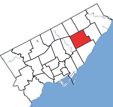 | ||
Scarborough Centre (French: Scarborough-Centre) is a federal electoral district in Ontario, Canada, that has been represented in the House of Commons of Canada since 1979.
Contents
The riding was created in 1976 from parts of Scarborough East, Scarborough West and York—Scarborough ridings.
It consists of the part of the Scarborough district of the City of Toronto bounded:
Notable landmarks in Scarborough Centre include:
It has been represented in the House of Commons by Liberal MP Salma Zahid since 2015.
Geography
The riding contains the neighbourhoods of Scarborough City Centre (west of McCowan Road), Bendale (west of McCowan and south of Lawrence), Eglinton East, Ionview (north of Eglinton Avenue), Golden Mile (north of Eglinton Avenue), Wexford, Maryvale, and Dorset Park.
History
Scarborough Centre was created in 1976. It consisted initially of the part of the Borough of Scarborough bounded on the west by Victoria Park Avenue, on the north by Ellesmere Road, on the east by Bellamy Road North, and on the south by Eglinton Avenue East.
In 1987, it was expanded to include the part of Scarborough lying bounded by Bellamy Road North, Lawrence Avenue East, Markham Road and Eglinton Avenue East.
In 1996, it was redefined such that it was bounded:
In 2003, it was given its current boundaries as described above.
This riding lost territory to Scarborough—Guildwood, and gained territory from Scarborough Southwest during the 2012 electoral redistribution.
Members of Parliament
This riding has elected the following Members of Parliament:
Election results
Note: Conservative vote is compared to the total of the Canadian Alliance vote and Progressive Conservative vote in 2000 election.
Note: Canadian Alliance vote is compared to the Reform vote in 1997 election.