
Time zone IRST (UTC+3:30) Area 2,078 km² | Capital Polsefid Website lindi.ir | |
 | ||
Bakhsh (Districts) Central District, Shirgah District | ||
Savadkuh County (also Savadkooh) (Persian: شهرستان سوادکوه) is a county in Mazandaran Province in Iran. At the 2006 census, the county's population was 66,430, in 17,918 families. The county is subdivided into two districts: the Central District and Shirgah District. The county has six cities: Zirab, Shirgah, Alasht, and Pol-e Sefid.
Contents
- Savdkuh consists of four cities
- Historical background
- Language
- Natural attractions
- Balu Bridge
- Urim Rudbr Church
- References
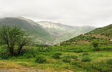
Covering an area of 2,441 square kilometres (942 sq mi), Savâdkuh is at the centre of Mazandaran Province. It is limited northward by Qaemŝahr, westward by Babol, eastward by Sari, southward by the Alborz mountain range and Tehran, and southeast by Semnan province. The main part of this city is located in a valley, in the central Alborz region, where Tâlâr river passes.
The tallest summit of Savâdkuh, is Arfa- Kuh, with a height of 3,500 metres (11,500 ft). The most important rivers flowing in this city are Tâlâr and Babol-rud, which originate from the Alborz mountain range standing southeast and southwest of Savâdkuh. These rivers irrigate the farmlands in Babol, Babolsar and Qaemŝahr.Including two areas of mountain in the north and foothill in the south, the mountainous area has a temperate and humid climate, and the weather in the south is dry and cold.
Savâdkuh consists of four cities
Savâdkuh consists of four cities, PolSefid, Zirab, Shirgah and Alasht; two districts Central and Ŝirgâh; and 6 hamlets, Ŝarq o Qarbe Ŝirgâh, Lafur, Sorx-kolâ, Valupei, Rastopei and Kassiliyân. Having 250 seasonal and permanent villages, the language spoken in Savâdkuh is Mazandarani. Its native inhabitants are Shiite Muslims.
The farmlands in Savâdkuh are limited because of its large forests and mountainous areas. So the farmers use their crops themselves, including rice, wheat, barley and sugar cane. According to geographical features, the economy of this city is based on apiculture and animal husbandry, more than agriculture.
Historical background
Darius I, the great Achaemenian monarch in his famous inscription in Behistun, mentions Pâtišvâreš as one of the territories under his rule. This Old Persian form subsequently became Middle Persian Pateŝxârgar and, following the Arab conquest, Perso-Arabic Faršavâdjar. The Greek historiographer Strabo records this name as Prâxovâtrâs.
In his inscription at Ka'ba-ye Zartosht, the second Sassanid monarch Shapur I, refers to the region as Pâdešxâr. In the Book of Deeds of Ardashir, Son of Babag, it is Patešxâr again. Ebne Esfandiar and Mir Zahirod-Dine Mara‘shi – the old geographers of Mazandaran – give its name as Patešxârgar as a large area in present-day Mazandaran, including Azerbaijan, Gilan, Tabaristan, Kumesh and Damghan.
Mohammad Hassan Khan (Etemad Saltaneh's Tadvin Fi Ahval Jebal Ŝervin, History of Savâdkuh) mentions it as the old name of the ancient area of Savâdkuh. They believe that the word "Savad" was distorted and changed to Faršavât. Savâdkuh enjoyed great importance in the history of Tabaristan and even in Iran.
Its tall mountains were the feudal seats of the Bavand dynasty, with which the Karan-Vands were allied. They defended the area against the invasions of the Amawid and Abbasids and tried to preserve their Zoroastrian religion and culture. The existence of numerous fortresses and military fortifications that date to the 8th-10th centuries vindicate this claim. In addition, Lajim tower with its 10th century brick-face inscription in Pahlavi script demonstrates the attention of the Savâdkuhs to the script, language and customs of their ancestors. The population of this region composed many poems, describing the heroic efforts and bravery of their notables.
Language
The languages spoken in Savâdkuh are Mazandarani and Persian, for the major part; and Mazandarani and Persian for the inhabitants of the villages.
Natural attractions
The most important natural attractions of Savâdkuh are: Ŝur Mâst lake, near a village by the same name, Gâzu waterfall in Lafur hamlet, waterfalls of Ŝirgâ and Gaduk, the mountains of Arfa Kuh, Sangâr and Qadamgâ, in Rassto Pei hamlet and Shervin mountain in Valu Pei hamlet; and Alaŝt city.
Balu Bridge
Located along the Ŝirgâh-Zirab road, near Talar river, it was made of fired bricks and mortar. The main part of this bridge was destroyed because of breaking, and now two herring-bone-shaped arches remained intact. One of them is 3 metres (9.8 ft) wide and 4.75 metres (15.6 ft) high, and another is 4.5 metres (15 ft) wide and 5.50 metres (18.0 ft) high. According to its architectural features, it probably dates back to before the Safavid dynasty.
Urim Rudbâr Church
This monument was built, following the erection of the northern Iranian railway. It was used for religious ceremonies by foreign personnel. The church consists of a chamber, measuring 4.20 by 5.20 metres (13.8 by 17.1 ft). With a height of 4 metres (13 ft), it houses a prayer niche and four cement candlesticks. The construction was made of stone and cement.