
Area 140.1 km² | Time zone BST (UTC+6) | |
 | ||
Website Official Map of Saturia | ||
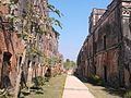
Baliati jamidar bari manikganj saturia
Saturia (Bengali: সাটুরিয়া) is an Upazila of Manikganj District in the Division of Dhaka, Bangladesh.
Contents
- Baliati jamidar bari manikganj saturia
- Map of Saturia Bangladesh
- Geography
- Demographics
- Administration
- Education
- References
Map of Saturia, Bangladesh
Geography
Saturia is located at 23.5925°N 90.0231°E / 23.5925; 90.0231 . It has 27174 households and total area 140.12 km².
Demographics
As of the 1991 Bangladesh census, Saturia has a population of 140215. Males constitute 49.84% of the population, and females 50.16%. This Upazila's eighteen up population is 73439. Saturia has an average literacy rate of 22% (7+ years), and the national average of 32.4% literate.
Administration
Saturia has 9 Unions/Wards, 165 Mauzas/Mahallas, and 215 villages.
The Upozila Parishad Office is at The Village name Baliati.
Education
According to Banglapedia, Baliati Iswar Chandra High School, founded in 1919, is a notable secondary school.
References
Saturia Upazila Wikipedia(Text) CC BY-SA