
Country Samoa | Time zone -11 | |
 | ||
Satupa'itea is a large village district with four sub-villages on the south east coast of Savai'i Island in Samoa.
Contents
- Map of Satupaitea Samoa
- Satupaitea village enclave
- Satupaitea Political District
- 19th century Methodist mission
- References
Map of Satupa'itea, Samoa
In the country's modern political divisions, Satupa'itea is also a Political District (Itumalo), one of 11 in the country, which now includes the traditional area of Salega.
Satupa'itea village enclave
The four villages in Satupa'itea village enclave are Moasula, Pitonu'u, Satufia and Vaega. The total population of Satupa'itea village enclave is 1799 (2006 Census).
Satupa'itea Political District
In modern politics, Satupa'itea district incorporates the larger traditional area of Salega (population 3,461).
Geographically, the district consists of two divisions separated by Palauli district.
The paramount chiefly title of the district is Tonumaipe'a, with special relevance in the Alataua sub-district (the western half of the district).
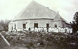
19th century Methodist mission
During the 19th century, Satupa'itea was an important stronghold for the early Methodist mission in Samoa. The English Methodist missionary George Brown (1835–1917) arrived in Samoa in 1860 and lived with his wife Lydia in Satupa'itea. They lived in a bamboo hut for the first two years and later constructed a mission house. In 1863, Brown began to train teachers at Satupa'itea for the ministry. The 'training' for the Methodist ministry was later established, in 1868, at Lufilufi on the north coast of Upolu island as the Piula Theological College.