
District West Godavari Time zone IST (UTC+5:30) Area 140 ha | PIN 534 007 Population 6,393 (2011) | |
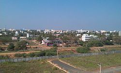 | ||
Eluru present position at satrampadu on vijayawada road as on 26 12 2016
Satrampadu is a census town in West Godavari district of the Indian state of Andhra Pradesh. It is located in Eluru mandal of Eluru revenue division. The town is a constituent of Eluru urban agglomeration.
Contents
Satrampadu eluru city eluru west godavari dist andhra pradesh india 29 01 2015
Demographics
As of 2011 census of India, Satrampadu had a population of 6393. The total population constitute, 3,153 males and 3,240 females —a sex ratio of 1023 females per 1000 males. 533 children are in the age group of 0–6 years with child sex ratio of 1090 girls per 1000 boys. The average literacy rate stands at 88.45% with 5654 literates.
Transport
Satrampadu is well connected by road. Eluru New bus station and old bus station are the nearest bus stations. State run APSRTC buses provides transport services from Satrampadu. Vatluru railway station is the nearest railway station at a distance of 2 mi (3.2 km). Eluru railway station 7.5 mi (12.1 km) and Powerpet railway station 5.5 mi (8.9 km) are nearby stations with both passenger and freight services.
Education
The primary and secondary school education is imparted by government, aided and private schools, under the School Education Department of the state. The medium of instruction followed by different schools are English, Telugu.