
North end: Hwy 55 Polwarth Length 22.9 km | Rural
municipalities: Canwood Province Saskatchewan | |
 | ||
South end: Hwy 3 in the Canwood RM | ||
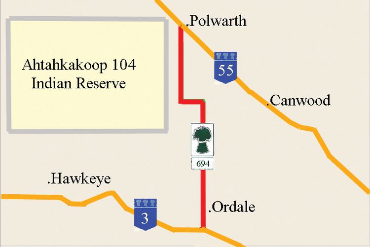
Saskatchewan Highway 694 connects Saskatchewan Highway 3 in the Canwood No. 494 rural municipality (RM) to Saskatchewan Highway 55 at Polwarth. South of Highway 55, Highway 694 is named Hilldrop Road. The length of Highway 694 is 22.9 kilometres (14.2 mi) and extends north, in the north central area of Saskatchewan west of Prince Albert.
Contents
Map of SK-694, Canwood, SK S0J 0K0, Canada
Communities
Polwarth is too small to be enumerated on its own, and in the 2006 census it was enumerated as a part of the RM of Canwood. Ahtahkakoop 104 Indian reserve is populated with 1,101 residents.
Rural municipalities
The RM of Canwood has a population of 1,535 residents. Canwood No. 494 was firstly formed as Rural Municipality Thompson from January 1, 1913 to April 29, 1916 before changing names to Canwood No. 494.
Travel Route
Highway 694 begins west of Shellbrook and east of Shell Lake. Highway 694 extends north 22.9 kilometres (14.2 mi) to the Highway 551 intersection. At Km 2.0 Highway 694 intersects with the range road which provides access to Ordale west of the highway. The highway turns sharply to the west at Km 13.2. Continue bearing west until Km 15.3, when the highway returns to the northerly direction. The land area reserved for Indian reserve Ahtahkakoop 104 is west of the highway. Continuing west on the range road will provide a thoroughfare into the Indian reserve. The terminus of Highway 694 is at Polwarth, at the Saskatchewan Highway 55 intersection.
Highway 694 has no intersections with any major road.