
Rural
municipalities: Shellbrook No. 493 Province Saskatchewan | Length 37.8 km | |
 | ||
South end: Hwy 3 at Shellbrook and Crutwell North end: Hwy 2 Prince Albert National Park | ||
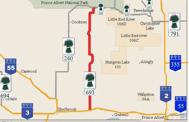
Saskatchewan Highway 693 connects the Saskatchewan Highway 3 Saskatchewan Highway 55 concurrency near Shellbrook to Saskatchewan Highway 240 in the Prince Albert National Park. The length of Highway 693 in north central Saskatchewan, Canada is 44.2 kilometres (27.5 mi).
Contents
Map of SK-693, Saskatchewan, Canada
Communities
Sturgeon Lake Indian Reserve No. 101 is located east of Highway 693. The Reserve extends from its western boundary at Highway 693, and its eastern boundary is on the shoreline of Sturgeon Lake (Saskatchewan).
Rural municipalities
Shellbrook No. 493 is an agricultural community harvesting spring wheat, canola, barley, alfalfa, and dry field peas. Mixed farming ventures support cattle and a minimal amount of pigs in the area. The community is situated near the northern edge of agricultural settlement in the transition zone between the aspen parkland and boreal forest biomes and as the early settlers arrived the land had to be cleared of the jack pine Forests before crops could be planted. The trees, however, provided an early cash crop and logs were rafted into Prince Albert where many were converted into railway ties.
Travel Route
Highway 693 begins at the junction of the concurrrency of Saskatchewan Highway 55 and Saskatchewan Highway 3 near Shellbrook in the rural municipality (RM) of Shellbrook No. 493 and extends north 37.8 kilometres (23.5 mi) to Highway 240 in the Prince Albert National Park. Shellbrook is west of the beginning terminus by 13.2 kilometres (8.2 mi), and Crutwell is east 11.8 kilometres (7.3 mi). At km 0.0, travel on Highway 693 is north. At km 17.8, Highway 693 turns east. At km 18.6, it returns northward traveling along the western edge of Sturgeon Lake Indian Reserve. Highway 693 continues North till Km 21.8 when turns west departing from the western boundary of Indian Reserve 101. At Km 24.4 Highway 693 travels north. Then at Km 40.4, Highway 693 turns east for 1.5 kilometres (0.93 mi). At Km 41.9 the highway returns to its northern routing. At Km 43.3, there is a turn in a northeast direction. The final mile post is Km 44.2 when Highway 693 connects with the terminal junction at Saskatchewan Highway 240 in the Prince Albert National Park.